Do Border Patrol agents still board Amtrak trains in NY and elsewhere?

Amtrak Unlimited Discussion Forum

Help Support Amtrak Unlimited Discussion Forum:

This site may earn a commission from merchant affiliate links, including eBay, Amazon, and others.
That one South of Lake Placid was dangerous. They used to wade out into I87 and wave little slow down signs and stop signs at cars and trucks going 70 mph. After a while they set up the cone lines and electric signs, but honestly if anyone coming here to cause a problem made it 70+ miles south of the border crossing, they wouldn't go down I87 through a well known checkpoint.
What other road
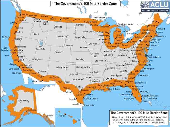
I drove I-87 south from Rouse's Point to North Hudson (well beyond Lake Placid), and there were no checkpoints.

About 10 years ago, I drove though one set up on I-91 right before White River Junction. Pointless as well, because there were lots of alternate routes around it.

Out west it's different. There's one on US 90 about 20 miles east of Uvalde, TX that's pretty hard to bypass, though there is a local road northeast out of Bracketville that will do the job. There's one on I-5 north of San Diego in the middle of Camp Pendleton that's impossible to bypass. I'm not sure whethere's there's a checkpoint on I-15, I've never driven that one.
 
The I-87 check point has probably been gone for at least 10 years now. Might be a bit longer than that, don't really recall just when they abandoned it.
 
I'm thinking in the ten year range also, give or take a few in either direction. I used to run some programs at the Olympic Training Center in LP, and passed it a few times. OTC didn't have a driver one day and I took a USOC van down to Albany Airport to pick up some coaches, just got a wave. Most of the time it was closed when I went through, going home even when it was still there. Everyone knows terrorists, smugglers and people sneaking in to the country don't work nights and weekends.
 
Not very hard at all.

And there are alternatives to I-87.

Not to mention the fact that someone sneaking over the boarder north of that area would be far more likely to board a bus, or maybe the Adirondack, than to rent/steal a car.
 
That one South of Lake Placid was dangerous. They used to wade out into I87 and wave little slow down signs and stop signs at cars and trucks going 70 mph. After a while they set up the cone lines and electric signs, but honestly if anyone coming here to cause a problem made it 70+ miles south of the border crossing, they wouldn't go down I87 through a well known checkpoint.
What other road

Doesn't change things. The ship is just like the airport; they can board the ship because it's coming from abroad. But they cannot board the train at ALB because of that. Albany itself is not within 100 miles of a border.
true, but Albany is basically trapped in the middle of those zones:

I haven't looked at this map in a while. It just occurred to me that a lot of Amtrak train go through the 100-mile border zone.

constitutionfreezonemap.jpg
How does the Lake Michigan shoreline count as a "coastal border?" Maybe the northern parts, near the Straits of Mackinac are within 100 miles of Canada, but to say that the shoreline at Chicago is the "border," when the other side of the lake is Michigan and the nearest foreign territory (Windsor, ON) is over 230 miles away, is taking things a little too far. Either the ACLU is mistaken, or Homeland Security doesn't know what it's doing.
 
Last edited by a moderator:
The ACLU has been lying about how many people are affected by the 100 miles for years. There are other parts of the map that are wrong. The border is a line roughly half way down the middle of the 4 border Great Lakes but the map shows 100 miles from the shoreline. It shows most of northern Wisconsin in the 100 mile zone while the only part that is within 100 miles of the actual border is a small part near The Apostle Islands. About half of the 100 mile zone near Upper Michigan is the open water of Lake Superior. The map may also be wrong along the oceans because the actual border is the 12 mile limit, not the shoreline so only 88 miles in is in the zone.
 
The ACLU has been lying about how many people are affected by the 100 miles for years. There are other parts of the map that are wrong. The border is a line roughly half way down the middle of the 4 border Great Lakes but the map shows 100 miles from the shoreline. It shows most of northern Wisconsin in the 100 mile zone while the only part that is within 100 miles of the actual border is a small part near The Apostle Islands. About half of the 100 mile zone near Upper Michigan is the open water of Lake Superior. The map may also be wrong along the oceans because the actual border is the 12 mile limit, not the shoreline so only 88 miles in is in the zone.
Isn't the issue here where Border Patrol considers itself authorized to go, not whatever anyone else thinks the 100-mile limit ought to be?

Is the ACLU's map correctly reporting where the Border Patrol goes? (That's a different question from: Is either the Border Patrol or ACLU over-reaching in its interpretation of the 100-mile limit, and if so, which one of them is over-reaching?)
 
Things are not as simple as we sitting in our armchairs and deciding that because the other shore is in the US therefore Lake Michigan is not international waters. :)

I actually took the trouble to dig into this and found a fascinating rat-hole in and of itself... Here is a quick summary:

The Article I, para 2, of the Boundary Water Treaty of 1909 between US and the Dominion of Canada representing the British Empire, explicitly defines Lake Michigan to be one of Great Lakes that is international water, in addition to the four that actually have shores both on the Canadian and US sides. That is the basis for defining the shoreline of Lake Michigan as coastal boundary for the purposes of commerce and immigration. Short of abrogating that Treaty which both sides like and have no intention of changing, that is where the border of US lies. ACLU is not wrong. There is apparently considerable historical legal basis for what they are saying regarding the location of the border (for the purposes of commerce and immigration which is what is CBP and ICE's remit) as they apply to the Great Lakes, and apparently the DHS is happy to agree with their position.

Note that the Great Lakes Coastal Boundary definition is entirely based on this aforementioned treaty, and it is interesting because by this treaty, waters that would otherwise be arguably entirely within the US are set up as freely navigable by both parties (actually the US and the Dominion of Canada representing the "Empire" of United Kingdom (don't know exactly what part of the 1909 Empire retains residual rights or not. The specific mention of the Dominion of Canada would suggest that none other than Canada today has any residual rights that accrue to them from this treaty) . All of the real coastal boundary facing an ocean or a sea is defined in 46 CFR Part 7, and it says nothing about the Great Lakes.
 
Last edited by a moderator:
Additionally, for the purpose of establishing the 100-mile zone from an international body of water, CBP measures from the shoreline, not from the 12-nautical mile territorial limit. So, yes, for better or worse, the map produced by the ACLU appears to be correct.
 
Things are not as simple as we sitting in our armchairs and deciding that because the other shore is in the US therefore Lake Michigan is not international waters. :)

I actually took the trouble to dig into this and found a fascinating rat-hole in and of itself... Here is a quick summary:

The Article I, para 2, of the Boundary Water Treaty of 1909 between US and the British Empire explicitly defines Lake Michigan to be one of Great Lakes that is international water, in addition to the four that actually have shores both on the Canadian and US sides. That is the basis for defining the shoreline of Lake Michigan as coastal boundary for the purposes of commerce and immigration. Short of abrogating that Treaty which both sides like and have no intention of changing, that is where the border of US lies. ACLU is not wrong. There is apparently considerable historical legal basis for what they are saying regarding the location of the border (for the purposes of commerce and immigration which is what is CBP and ICE's remit) as they apply to the Great Lakes, and apparently the DHS is happy to agree with their position.

Note that the Great Lakes Coastal Boundary definition is entirely based on this aforementioned treaty, and it is interesting because by this treaty, waters that would otherwise be arguably entirely within the US are set up as freely navigable by both parties (actually the US and The "Empire" of United Kingdom (don't know exactly what part of the 1909 Empire retains residual rights or not) . All of the real coastal boundary facing an ocean or a sea is defined in 46 CFR Part 7, and it says nothing about the Great Lakes.
Man, that is a rathole!

I would interpret what you wrote is saying that a Canadian (or someone who is in Canadian territory) can freely navigate from the Canadian side of Lake Huron, sail through the Straits of Mackinac and into Lake Michigan right up to Chicago or Indiana before they have to report to US Customs and Immigration. I would guess it also allows US individuals to navigate freely on the Canadian side of the Great Lakes/Detroit River/St Lawrence River, etc. Does this "international waters" business apply only to Americans and Canadians (and British (?)), or is the entire St, Lawrence Seaway/Great Lakes considered international waters, allowing all foreign ships free passage from the Atlantic to Duluth and Chicago? Does it mean that the SS Badger, once it sails into "international waters" off Manitowoc and Ludington can open a gambling casino (without Indian help) and sell booze to 18 year olds?

Still, the chances that there are scary foreigners (even Canadians!) skulking about in the "international waters" off of Lake Michigan seems to me to be so low that if I were the secretary of Homeland Security, I would not bother deploying the Border Patrol along the shores of Lake Michigan. As for dealing unauthorized immigrants residing in the areas around Lake Michigan, well, that's what ICE is for, no? The Border Patrol should be deploying its resources to the real border, not the legal fiction border.
 
"The Article I, para 2, of the Boundary Water Treaty of 1909 between US and the British Empire"

Actually between "The United States of America and His Majesty the King of the United Kingdom of Great Britain and Ireland and of the British Dominions beyond the Seas, Emperor of India."

"Note that the Great Lakes Coastal Boundary definition is entirely based on this aforementioned treaty, and it is interesting because by this treaty, waters that would otherwise be arguably entirely within the US are set up as freely navigable by both parties (actually the US and The "Empire" of United Kingdom (don't know exactly what part of the 1909 Empire retains residual rights or not) ."

If you look at the text:

"being equally desirous to prevent disputes regarding the use of boundary waters and to settle all questions which are now pending between the United States and the Dominion of Canada involving the rights, obligations, or interests of either in relation to the other or to the inhabitants of the other, along their common frontier, "

"ARTICLE I

The High Contracting Parties agree that the navigation of all navigable boundary waters shall forever continue free and open for the purposes of commerce to the inhabitants and to the ships, vessels, and boats of both countries equally, subject, however, to any laws and regulations of either country, within its own territory, not inconsistent with such privilege of free navigation and applying equally and without discrimination to the inhabitants, ships, vessels, and boats of both countries."

it would seem that the treaty applies only to the United States and Canada. Back in 1909, I guess London felt that the Canadians weren't able to negotiate their own treaties. The actual agreement was concluded between the US Secretary of State and the British ambassador to Washington. I wonder if there was any Canadian input at all.
 
it would seem that the treaty applies only to the United States and Canada. Back in 1909, I guess London felt that the Canadians weren't able to negotiate their own treaties. The actual agreement was concluded between the US Secretary of State and the British ambassador to Washington. I wonder if there was any Canadian input at all.
I would certainly hope so... don't think it's anybody's best interest to see Russian or Chinese navy ships or submarines sailing on Lake Michigan.

Although I could swear seeing a National Geographic photo that showed a huge Chinese-flagged cargo ship sailing on Lake Michigan, carrying grains and stuff destined for China.
 
No wonder the State Department and International Diplomacy is such a "Puzzle Palace!"

Cue up Gordon Lightfoot singing "The Wreck of the Edmund Fitzgerald" and call in the International Marine Lawyers!

Interesting topic for sure!
 
I would certainly hope so... don't think it's anybody's best interest to see Russian or Chinese navy ships or submarines sailing on Lake Michigan.

Although I could swear seeing a National Geographic photo that showed a huge Chinese-flagged cargo ship sailing on Lake Michigan, carrying grains and stuff destined for China.
Neither the Russians nor the Chinese were part of the British Empire ever, so the Treaty would not even potentially apply to them (well barring Hong Kong I suppose :) ).

Potentially it could only be other parts of what used to be the British Empire. However, I tend to agree with MARC Rider that the treaty in its intent restricts itself to the Dominion of Canada representing the British Empire.

However, either the US or the Canadians can permit ships of other countries which have duly been allowed to operate in their waters for a specific purpose, like take some cargo brought from outside the US to a specific port. So nothing surprising in seeing a Chinese flagged carrier. It is indeed quite possible that US itself allowed that. This is no different than a ship being allowed to sail up the Savannah River to the Port of Savannah GA, or up the Columbia and Willamette Rivers upto the Port of Portland OR.
 
Last edited by a moderator:
No wonder the State Department and International Diplomacy is such a "Puzzle Palace!"

Cue up Gordon Lightfoot singing "The Wreck of the Edmund Fitzgerald" and call in the International Marine Lawyers!

Interesting topic for sure!
You have not even seen any of the mess that the British left in the partition of India in the form of the Radcliffe Award, specially in the east, and the consequent borders. There were areas where there were Indian enclave within what is Bangladesh today (was East Pakistan between 1947 and 1971) and vice versa. And there were a few instances where there was a Bangladesh enclave within an Indian enclave within Bangladesh, with no way for the Bangladehsis in the inner enclave to get to the rest of Bangladesh without going through India!!! There were a couple with the roles reversed too!!! A very recent treaty between India and Bangladesh did a significant exchange of land and people to get rid of this mess after 69 years, to straighten out the borders and get rid of all, enclaves. Of course meandering and moving river beds that were used to define some borders did not help much either. Now it is all defined using actual GPS based definition.
 
US port to US port with no foreign port in between usually equals Jones Act (US flagged and crewed, usually built, at least keeled) US port to/from foreign port, usually foreign flagged even if it has a US parent company and name. (like most cruise ships) Plenty of foreign ships traverse the St Lawrence, and go through the Welland locks, and on to the midwest. It is where lots of US grain is exported from.
 
US port to US port with no foreign port in between usually equals Jones Act (US flagged and crewed, usually built, at least keeled) US port to/from foreign port, usually foreign flagged even if it has a US parent company and name. (like most cruise ships) Plenty of foreign ships traverse the St Lawrence, and go through the Welland locks, and on to the midwest. It is where lots of US grain is exported from.
Exactly!
 
Does it mean that the SS Badger, once it sails into "international waters" off Manitowoc and Ludington can open a gambling casino (without Indian help) and sell booze to 18 year olds?
Don't know about selling booze to 18 years olds, but gambling Casinos apparently operate on boats in the Great Lakes already, under Indiana Law as it turns out :)

http://traveltips.usatoday.com/riverboat-casinos-lake-michigan-103595.html

Actually I have no idea what maritime laws apply in the Great Lakes since the entire lot is a special case, and the 12 mile thing does not apply, or well, perhaps applies in some strange way buried in some paragraph of some regulation.
wait... maritime laws? :) this thread has gone so far astray from Amtrak :D

next we'll shift into discussion about UN Outer Space Treaty (which the

United States ratified 50 years ago, just before the creation of Amtrak) :)
 
Last edited by a moderator:
Back
Top