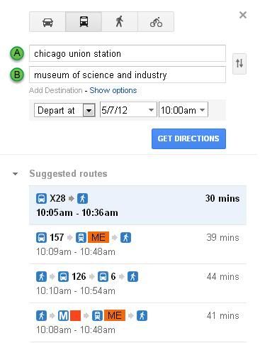
As an example, using Google Transit, here are the public transportation options from Union Station to the Museum of Science and Industry.
I used Monday, May 7th and 9:30 am as the departure date and time.
You'd have to walk to Michigan Ave. to catch the #10 and to State St. to catch the #6
The X28 - Stoney Island Express stops in front of CUS, the old building on the west side of Canal - just look at the bus stop signs to make sure you're at the right one.
I generally don't mention the X28 because it only operates during rush hours on weekdays, and therefore isn't a reliable option for folks whose train may be late (or aren't going directly to the museum from the train station) or who are traveling on weekends. Usually, posters don't mention the day of week they're traveling (and sometimes, though not this case, they don't even mention the time of year).
If the X28 happens to be available, great. Nothing lost by using it.
As for relying on Google Transit, it is useful for planning on specific trips. However, one thing pretty much every online transit trip planner fails to do (at least, all that I've seen), is really give the traveler the sense of what options/alternatives are available, and which ones are preferable. If you don't know exactly when you're going to be traveling, but just want a general sense of what you could do, the trip planner isn't useful.
Someone could do a hypothetical search for info from Chicago Union Station to Museum of Science and Industry at 10:00 am and see that there is an X28 at 10:05 am. What it doesn't tell you is that if you get to the bus stop at 10:06 am, you can't use the X28 because the next one isn't until the afternoon.
Likewise, someone trying to get from Michigan/Delaware (near Water Tower) to the Chicago river at Michigan Avenue would check Google Transit and see a list of three bus routes they could take (some or all of which might be rush-hour only service, depending on the time entered). What Google Transit won't tell you, which is infinitely more useful, is to take ANY bus (well, except for the 33, but that only runs AM rush hours) from Michigan/Delaware southbound, because they will all take you there. There are seven bus route numbers you could take, but Google will only give you three options. Someone could spend 10-15 minutes waiting at the bus stop for the 145 to show up, while three 151s, two 147s and a 146 go by, because Google told them to take that specific route.
Even when they do give an accurate depiction of the alternative routings available, they don't list which ones are preferable based on frequency. This is important to know if you don't actually know when you'll be traveling. If you just miss the #10 out of the museum (on days when it's running), you could wait 20-30 minutes for the next one, or walk across the street to the #6 bus stop and catch a bus every 5-10 minutes.
I also suggest folks be careful of trip planners for their accuracy. While they should be accurate (and Google Transit usually is), the other Chicago transit trip planner, run by the RTA (a useless organization, don't get me started), called GoRoo (whatever that means) is horrible. Once, someone asked me to help them figure out how to get from their hotel in the Loop to a comedy club on the north side because the GoRoo planner didn't make any sense. I decided to try it out for myself, and the thing told me to walk six blocks to the Blue Line, ride it for one stop, then walk three miles to their destination. Never mind that the Brown Line not only was closer to both their origin and destination (requiring a total of a half mile of walking), but a bus would have been closer still. (And also never mind that the RTA spent millions of dollars building GoRoo, when they could have used Google Transit for free, but that's the RTA for you in Chicago, duplicating efforts while providing no real value...anyway, I shouldn't go on a rant about that because it will go on for pages).
Those of us who live in Chicago and are intimately familiar with the CTA system (including some who have worked there, in the planning department, and helped put together service schedules and the tourist map brochures and such) can provide much better "how to get there" info, with appropriate caveats, than any online trip planner ever could.