Changes Coming to METRO & THE Map

Amtrak Unlimited Discussion Forum

Help Support Amtrak Unlimited Discussion Forum:

This site may earn a commission from merchant affiliate links, including eBay, Amazon, and others.
The concept is more than vague, alternate routes for re-routes of the Blue through DC have been studied at a projected traffic level by the WMATA planners. There are viewgraph presentations posted last year on a number of alternate extensions and new lines they have analyzed at the http://planitmetro.com/ website. The alternate route for the Blue Line that gets some traction is to have go under the Rosslyn station, under the Potomac to Georgetown with 2 new stations in Georgetown, then turn east under M street, connect at Mt. Vernon Sq, then head SE to Union station providing a second Metro line at Union station, then reconnect to the current Blue line west of Stadium Armory where the Orange/Blue cross the Anacostia.
Like this one? Link

That shows Silver going on a new alignment (and skipping all the stations between Rosslyn and WFC) but the general concept seems sensible enough.

Though that sounds like it's about 30 years away
ph34r.gif
That is another alternative they have considered: Rerouting the Silver Line to parallel the Orange Line (along I-66 perhaps), connection at Rosslyn, then under the Potomac in new tunnels to Georgetown, and then M St to Union station. They looked at a bunch of alternatives not at any serious engineering detail, but in terms of projected traffic loads and which routes people might take.

I think the alternatives looked at in the 2010, 2011 presentations can be found on the TAG (Technical Advisory Group) board link: http://planitmetro.com/category/rtsp/tag/. Other alternative routes and extensions looked at included:

-a "Brown" line diverging off of the Red Line,

-Interline connections allowing Orange/Silver Line trains to go pass Arlington cemetery and then across the Yellow line bridge and east on the Green Line,

-Beltway line going ALL the way around DC following the Beltway and paralleling it in some parts. Mind-bogglingly expensive, but I have to give them points for modeling how many people might take it.

-Alternate new routes for the Yellow Line in DC,

-Blue Line to Georgetown and then SE to Constitution Avenue to Union Station,

-Orange, Blue, Green line extensions.

This is all in the very early stages of considering what the next steps are after the Silver Line is completed.

Other projects that have to be considered in traffic load analysis are the Purple light rail line (tentatively planned for circa 2020-2021 completion), the DC Streetcar plans, the BRT and Streetcar projects in Arlington & Alexandria.
 
Last edited by a moderator:
Outsider, who had no clue where NoMA is, many of whom also did no have a clue where Smithsonian is either.
If you showed them a Metro map, I bet they could have figured out which stop to get off at to go to the Smithsonian, however.
 
NoMA is just as real as those places, the opinion of one person 3,000 miles away notwithstanding.
You clearly don't understand the difference between "the stadium that the Yankees play in is named Yankee Stadium" and "we branded an existing area of an over one hundred year old city with the name 'NoMa.'"
If you ask anyone around where I live, where is the Lake House neighborhood, I sincerely doubt that you'd find anybody who has any idea. However, it's a real, legally defined neighborhood here. However, it's a location that was made up when some people wanted a historical district; residents of the area are more likely to define themselves as living in Delmas Park, which doesn't appear on a map anywhere. When they put in a light rail stop in the area, they didn't call it "Lake House," even though that's the area's name; it was named "San Fernando," after the street to which it is closest.

This is a similar situation. A bunch of businesses wanted to brand their area with a name; and so, "NoMa" was created out of thin air. If you browbeat people enough, they'll use the name; people did eventually figure out where the "Ogilvie Transportation Center" is. However, the government really shouldn't be doing that. Instead of forcing a name onto the people, they should be using a name that the people would use themselves.
 
As a rough guess, it looks like it's about 14 miles from West Falls Church to Largo. Toss another 23 miles on top for the Silver run to Dulles and you'd have a run of 37 miles one way.

The A train up in NYC is a little over 31 miles from 207th Street to Far Rockaway and it take almost 2 hours to make the run when running local (less if running express); so it's not like running end to end for the Silver line would be something outrageous and unheard of.
I don't have a DC Metro mileage map, so I traced the Orange/Blue lines on Google Earth. From where the Silver Line will merge with the Orange Line, it is about 13.8 miles to Stadium-Armory. Largo is about 8 miles on the Blue Line from Stadium-Armory.

So the Silver Line will be about 23 + 13.8 = ~37 miles from Rt. 772 in Ashburn to Stadium-Armory. Add 8 miles to Largo, it would be a ~45 mile trip. If the A train is the longest route in the NYC Subway system, the Silver Line (if/when it is fully built) might be the longest heavy rail route in the US even without going east of Stadium-Armory. What is the longest line or route in Chicago?

If it is not distance, then it may be predicted passenger traffic. The Silver Line will provide a one seat ride from Dulles to Tysons Corner to the city core through Capitol Hill to Stadium-Armory. How many passengers from Benning Road or Capitol Heights (east of Stadium-Armory) will be traveling to Tysons Corner or to Dulles? A few will, sure, but how many? People getting on at the eastern end of the Blue Line will be able to get to Dulles or Tysons with one station switch - with a whole bunch to stations to choose for switching to a Silver Line train.
 
Outsider, who had no clue where NoMA is, many of whom also did no have a clue where Smithsonian is either.
If you showed them a Metro map, I bet they could have figured out which stop to get off at to go to the Smithsonian, however.
True, but depending on which museum they were going to, they probably could have gotten off at a closer stop.

You clearly don't understand the difference between "the stadium that the Yankees play in is named Yankee Stadium" and "we branded an existing area of an over one hundred year old city with the name 'NoMa.'"
I understand, I just don't care. It doesn't make a difference. Especially since that area of the city didn't have an existing name that was well known by folks.
This is a similar situation. A bunch of businesses wanted to brand their area with a name; and so, "NoMa" was created out of thin air. If you browbeat people enough, they'll use the name; people did eventually figure out where the "Ogilvie Transportation Center" is. However, the government really shouldn't be doing that. Instead of forcing a name onto the people, they should be using a name that the people would use themselves.
Well it is a good thing the government isn't doing that, then.
 
As a rough guess, it looks like it's about 14 miles from West Falls Church to Largo. Toss another 23 miles on top for the Silver run to Dulles and you'd have a run of 37 miles one way.

The A train up in NYC is a little over 31 miles from 207th Street to Far Rockaway and it take almost 2 hours to make the run when running local (less if running express); so it's not like running end to end for the Silver line would be something outrageous and unheard of.
I don't have a DC Metro mileage map, so I traced the Orange/Blue lines on Google Earth. From where the Silver Line will merge with the Orange Line, it is about 13.8 miles to Stadium-Armory. Largo is about 8 miles on the Blue Line from Stadium-Armory.

So the Silver Line will be about 23 + 13.8 = ~37 miles from Rt. 772 in Ashburn to Stadium-Armory. Add 8 miles to Largo, it would be a ~45 mile trip. If the A train is the longest route in the NYC Subway system, the Silver Line (if/when it is fully built) might be the longest heavy rail route in the US even without going east of Stadium-Armory. What is the longest line or route in Chicago?
While I admit my calculation was a rough guess, I took the mileage from West Falls to Largo (this was the rough estimate) and added it to the mileages you supplied for the Silver I & II sections. So I'm quite surprised to see/hear that things have now jumped to 45 miles.

If it is not distance, then it may be predicted passenger traffic. The Silver Line will provide a one seat ride from Dulles to Tysons Corner to the city core through Capitol Hill to Stadium-Armory. How many passengers from Benning Road or Capitol Heights (east of Stadium-Armory) will be traveling to Tysons Corner or to Dulles? A few will, sure, but how many? People getting on at the eastern end of the Blue Line will be able to get to Dulles or Tysons with one station switch - with a whole bunch to stations to choose for switching to a Silver Line train.
This isn't about the convenience of Silver line riders being able to get to Largo with a one seat ride.

This is about the current Blue line passengers who board at stations between Stadium & Largo who will now have less frequent service if indeed the Silver's turn back at Stadium. Remember, they are now sending some former Blue line trains over the Yellow line tracks. IIRC, I'm posting from 2212 so it's too hard to go look, there are now 5 fewer Blue line trains per hour during rush hour going to Largo. For now the Orange line trains are filling that gap. But if the Silver's only run to Stadium, then they will not be filling that gap and those going further than Stadium will have less frequent service.
I believe that it is yellow line trains going on the blue, not the other way around. I think that while it would be long and take a lot of equipment, the Silver trains should go beyond Stadium-Armory. I think that the Blue and Orange should both run to their respective points, with the Silver Line splitting equally and serving both of them. This way, the stations past Stadium will not have any cutback in service, and there will need to be less transfers in general.
 
This is about the current Blue line passengers who board at stations between Stadium & Largo who will now have less frequent service if indeed the Silver's turn back at Stadium. Remember, they are now sending some former Blue line trains over the Yellow line tracks. IIRC, I'm posting from 2212 so it's too hard to go look, there are now 5 fewer Blue line trains per hour during rush hour going to Largo. For now the Orange line trains are filling that gap. But if the Silver's only run to Stadium, then they will not be filling that gap and those going further than Stadium will have less frequent service.
That end of the blue line isn't heavily used, so the less frequent service isn't going to be a huge deal.

I believe that it is yellow line trains going on the blue, not the other way around. I think that while it would be long and take a lot of equipment, the Silver trains should go beyond Stadium-Armory. I think that the Blue and Orange should both run to their respective points, with the Silver Line splitting equally and serving both of them. This way, the stations past Stadium will not have any cutback in service, and there will need to be less transfers in general.
Alan is right, Blue Line trains from Franconia-Springfield will be taking the Yellow Line route up through the center of the city.
Your idea would be a good one if the ridership was equal across all of the lines, but WMATA is doing it this way to run the trains where the demand for them exists.
 
This is about the current Blue line passengers who board at stations between Stadium & Largo who will now have less frequent service if indeed the Silver's turn back at Stadium. Remember, they are now sending some former Blue line trains over the Yellow line tracks. IIRC, I'm posting from 2212 so it's too hard to go look, there are now 5 fewer Blue line trains per hour during rush hour going to Largo. For now the Orange line trains are filling that gap. But if the Silver's only run to Stadium, then they will not be filling that gap and those going further than Stadium will have less frequent service.
That end of the blue line isn't heavily used, so the less frequent service isn't going to be a huge deal.
It may not be a big deal in terms of how crowded things are, but it is still a big deal to someone used to having a train come every 2 and a half minutes that now comes every 5 minutes; or whatever the actual timings will be.

And there is an additional consideration here; right now they're only pulling 5 Blue line trains per hour during rush hour. If we get a 1 to 1 correlation with the Silvers, that translates to one train every 12 minutes on the Silver line branch. I suspect that will not be enough service out on that line to meet the demand. I think that Metro is simply easing people into this new pattern and that when the time comes we'll see even more Blue line trains pulled from the Blue and sent via the Yellow line.

That in turn means even more reduced headways between Stadium-Armory and Largo Town Center. Plus who's to say that demand on that end of the line won't increase too, especially if the Purple line gets built.

I believe that it is yellow line trains going on the blue, not the other way around. I think that while it would be long and take a lot of equipment, the Silver trains should go beyond Stadium-Armory. I think that the Blue and Orange should both run to their respective points, with the Silver Line splitting equally and serving both of them. This way, the stations past Stadium will not have any cutback in service, and there will need to be less transfers in general.
Alan is right, Blue Line trains from Franconia-Springfield will be taking the Yellow Line route up through the center of the city.
To be more clear, some trains that are now Blue line trains are being "re-colored" to Yellow and will largely now operate on the Yellow line, but on the Southern end of the line they will take the switch to the Blue line (instead of the Yellow) and service the final two stops; Van Dorn & Franconia-Springfield.
 
This is about the current Blue line passengers who board at stations between Stadium & Largo who will now have less frequent service if indeed the Silver's turn back at Stadium. Remember, they are now sending some former Blue line trains over the Yellow line tracks. IIRC, I'm posting from 2212 so it's too hard to go look, there are now 5 fewer Blue line trains per hour during rush hour going to Largo. For now the Orange line trains are filling that gap. But if the Silver's only run to Stadium, then they will not be filling that gap and those going further than Stadium will have less frequent service.
That end of the blue line isn't heavily used, so the less frequent service isn't going to be a huge deal.
It will be a nuisance to those taking the Blue Line east of the Anacostia River. I had not thought about the service frequency hit those Blue Line stations will get. Because Prince George's County has done a poor job of taking advantage of the opportunity the Metro stations offer for higher density Transit Oriented Development and the increased tax base & revenue that comes with it, the stations in Prince George's are among the lower ridership stations in the system. With new leadership in the county and a more transit focused MD state government, that should change. Which should eventually result in TOD around those Blue Line stations and increased passenger base. When that starts to take place, WMATA should be flexible in adding service frequencies to the east end of the Blue Line.

I have not looked in depth at what the plans are for Phase 1 of the Silver Line which is 5 stations, 11.5 miles and scheduled to start by end of 2013, early 2014. They could have the Phase 1 Silver trains take over the Orange Line Rush Plus split past Stadium Armory and down the Blue Line to Largo Town Center. That would be around 33-34 miles.

One idea I saw floated on-line for the completed Silver Line is that the planners should build (or have built) a reverse switch track east of the Tysons East/McLean station. Much of the traffic on the Silver Line is going to be entirely on the Silver Line between Tysons, Reston, Herndon, Dulles, Ashburn. People will take the Silver to commute to Tysons from further west or to Tysons or Reston for shopping and evening activities. As Tysons evolves into the dense satellite city the plans call for, it will be a main destination for many further west on the Silver Line. If there was a turn-around switch and 3rd center track at the eastern end of Tysons, they could have, for example, every 3rd service frequency on the Silver Line turnaround at Tysons East/McLean and head back towards Dulles and Ashburn. That would alleviate the traffic load where the Silver, Orange, Blue lines meet at Rosslyn.

But what I have read, this idea is not part of the planning process, likely because in the transportation planners thinking, of course, all the trains have to go through the city core. Another one, which is touched on in the TAG presentations, is an interline connection at Rosslyn (expensive for sure) that would allow a Virginia only line running from Ashburn/Dulles to Huntington on the Yellow Line. Would allow direct Alexandria, Crystal City connections to Tysons and Dulles and take traffic load off of the core.
 
This is about the current Blue line passengers who board at stations between Stadium & Largo who will now have less frequent service if indeed the Silver's turn back at Stadium. Remember, they are now sending some former Blue line trains over the Yellow line tracks. IIRC, I'm posting from 2212 so it's too hard to go look, there are now 5 fewer Blue line trains per hour during rush hour going to Largo. For now the Orange line trains are filling that gap. But if the Silver's only run to Stadium, then they will not be filling that gap and those going further than Stadium will have less frequent service.
That end of the blue line isn't heavily used, so the less frequent service isn't going to be a huge deal.

I believe that it is yellow line trains going on the blue, not the other way around. I think that while it would be long and take a lot of equipment, the Silver trains should go beyond Stadium-Armory. I think that the Blue and Orange should both run to their respective points, with the Silver Line splitting equally and serving both of them. This way, the stations past Stadium will not have any cutback in service, and there will need to be less transfers in general.
Alan is right, Blue Line trains from Franconia-Springfield will be taking the Yellow Line route up through the center of the city.
Your idea would be a good one if the ridership was equal across all of the lines, but WMATA is doing it this way to run the trains where the demand for them exists.
The Blue Line is going over the bridge with the yellow?

Edit: OK, I went and read a WMATA press release about the service and the reason I was confused is that they said that the trains would be Blue Line trains going to Greenbelt and being identified as a Yellow. Thanks for trying to clarify, but my sleepy teenage brain sometimes won't hold in all of the info it should. :)
 
Last edited by a moderator:
This is about the current Blue line passengers who board at stations between Stadium & Largo who will now have less frequent service if indeed the Silver's turn back at Stadium. Remember, they are now sending some former Blue line trains over the Yellow line tracks. IIRC, I'm posting from 2212 so it's too hard to go look, there are now 5 fewer Blue line trains per hour during rush hour going to Largo. For now the Orange line trains are filling that gap. But if the Silver's only run to Stadium, then they will not be filling that gap and those going further than Stadium will have less frequent service.
That end of the blue line isn't heavily used, so the less frequent service isn't going to be a huge deal.

I believe that it is yellow line trains going on the blue, not the other way around. I think that while it would be long and take a lot of equipment, the Silver trains should go beyond Stadium-Armory. I think that the Blue and Orange should both run to their respective points, with the Silver Line splitting equally and serving both of them. This way, the stations past Stadium will not have any cutback in service, and there will need to be less transfers in general.
Alan is right, Blue Line trains from Franconia-Springfield will be taking the Yellow Line route up through the center of the city.
Your idea would be a good one if the ridership was equal across all of the lines, but WMATA is doing it this way to run the trains where the demand for them exists.
The Blue Line is going over the bridge with the yellow?
Yes, select Blue line trains will become Yellow line trains and start at Franconia and then run over the bridge on the Yellow line to the terminus. So on the current Blue line at the last two stations, you will now see two colors much like you do for the rest of the line in Virginia.
 
]It may not be a big deal in terms of how crowded things are, but it is still a big deal to someone used to having a train come every 2 and a half minutes that now comes every 5 minutes; or whatever the actual timings will be.
True, but it'll be a big deal for a relatively small number of people.
That in turn means even more reduced headways between Stadium-Armory and Largo Town Center. Plus who's to say that demand on that end of the line won't increase too, especially if the Purple line gets built.
If demand changes, they can always adjust the mix of orange/blue trains to accommodate. If anything, the purple line will increase demand at New Carrollton, as that will be the eastern terminus of the line. The blue line will not be impacted by the purple line.
 
This is a similar situation. A bunch of businesses wanted to brand their area with a name; and so, "NoMa" was created out of thin air. If you browbeat people enough, they'll use the name; people did eventually figure out where the "Ogilvie Transportation Center" is. However, the government really shouldn't be doing that. Instead of forcing a name onto the people, they should be using a name that the people would use themselves.
Well it is a good thing the government isn't doing that, then.
So are they not naming the station "NoMa," or are you just being flippant?
I think he is just pulling your leg, since NoMA is neither the first time nor the last time that such name changes have occurred or will occur. You can continue whistling in the wind meanwhile. :)

City governments and real estate interests are always closely intertwined and that is one of the main mechanisms by which cities try to enhance their tax base. So it is to be expected that cities will work with the real estate interests to enhance visibility of their projects where it serves the city's purposes. Street and locality names are changed all the time based on such considerations. If a subway station gets caught in the act, so be it. If you can't understand that simple fact, then it is hard to have an intelligent discussion.

Some of the more famous changes of names in cities include renaming of Longacre Square to Times Square after New York Times built their building at the location in 1904. The change of name of a huge locality to World Trade Center in downtown Manhattan over the objections of the local residents, including change of name of a subway station and a PATH station. This was a real estate development by the government itself through its Port Authority. The change of name of a Green Line Station in Boston to Haynes after Haynes Center opened, and also the name of Mechanic station was changed to Prudential Station based on Prudential's real estate development in Back Bay. And even the change of the name of 34th St station to 34th St. Pennsylvania after Pennsylvania Railroad chose to do their real estate development including their rail station in Manhattan adjacent to it. Stuff like this happens all the time. Now of course they are all established names and "real" to use your term, but they were not always so.
 
Last edited by a moderator:
This is a similar situation. A bunch of businesses wanted to brand their area with a name; and so, "NoMa" was created out of thin air. If you browbeat people enough, they'll use the name; people did eventually figure out where the "Ogilvie Transportation Center" is. However, the government really shouldn't be doing that. Instead of forcing a name onto the people, they should be using a name that the people would use themselves.
Well it is a good thing the government isn't doing that, then.
So are they not naming the station "NoMa," or are you just being flippant?
Neither. You're failing to understand that this isn't a "new" name. "The government" didn't invent the "NoMA" name. WMATA didn't invent the NoMA name. They're not "forcing a name onto the people". They're naming the station after the neighborhood that the station is located in. The "NoMA" name has been used to describe the area for years.

I'm not sure why that's so hard to wrap your head around.
 
Some of the more famous changes of names in cities include renaming of Longacre Square to Times Square after New York Times built their building at the location in 1904.
That's it. I refuse to fall under the thumb of the government forcing these contrived names on me. I'll never refer to Longacre Square as "Times Square" ever again.
 
"New York Avenue" was a terrible name for that station. New York Avenue is several miles long and the station isn't even on that street, it's on Florida. Even if it weren't an organic name, "NoMa" at least means a neighborhood rather than a very long street. That, and there seems to be a movement to rename street-named stations for their neighborhood-in addition to the NoMa rename, King Street is now King Street/Old Town.
 
Some of the more famous changes of names in cities include renaming of Longacre Square to Times Square after New York Times built their building at the location in 1904.
That's it. I refuse to fall under the thumb of the government forcing these contrived names on me. I'll never refer to Longacre Square as "Times Square" ever again.
In that case, if you are in the town that now goes by the name of Truth or Consequences, NM, insists on calling it Hot Springs, NM. The local guvmint officials renamed their town after the game show in the 1950s. How crassly commercial of them! :lol:

Quite a lot of fuss being raised by poster sechs over a created name, NoMa, for a neighborhood. The area did not have an identity and now it does with quite a lot of construction with office and residential buildings going up. Also should note, that NoMa includes the Uline Arena, directly east of the tracks and easily seen from the trains pulling in and out of Union Station. The Uline arena, currently used as an indoor parking lot and for placing large (illegal) billboards on it, has a claim to fame as the site of the first concert by the Beatles in the US.
 
Sorry to be late to the party. I've been very busy of late, and haven't been checking the site enough. I think I need to have Ryan page me whenever WMATA gets a thread here.

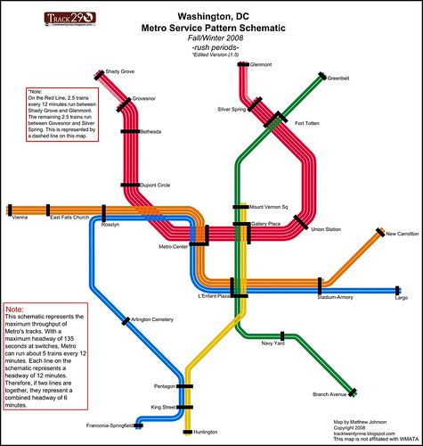
The Largo Branch Headways

It has been mentioned before, but I wanted to try to clarify the service patterns, especially with respect to the Largo branch of the Blue Line.

Currently the Largo branch (the "G Route") is served by 10 trains per hour (TPH) in each direction during rush hour. This means a train comes every 6 minutes in each direction. With the June service changes, 3 existing Blue Line trains per hour in each direction will become Yellow Line trains running from Franconia to Greenbelt (and Greenbelt to Franconia). This means that without any influx of new trains, the Largo branch would see a reduction to 7 TPH (8.5 min headway). So as a result, the newly added Orange Line trains will go to Largo, keeping the number of trains the same (10 TPH).

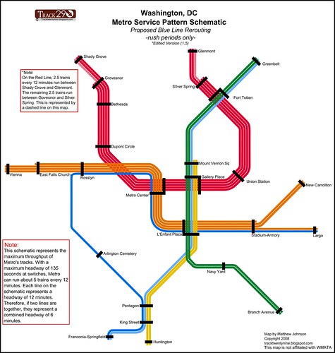
Once the Silver Line opens, some semblance of the June 2012 service pattern will need to be maintained or the terminals of the Silver and Blue lines will need to be swapped. Because unless some Silver trains continue to Largo, the G Route will see reduced headways. And in that case, it makes more sense to send all Silver trains to Largo, and terminate all Blue trains at Stadium/Armory, since the headways match better.

Let's look at the numbers. At any given point, a Metro track is limited to 26 trains per hour. The likely service pattern for the Blue/Orange/Silver subway is:

  • 10 TPH Orange
  • 10 TPH Silver
  • 6 TPH Blue
With that service pattern, since both the New Carrollton and Largo branches need to have 10 TPH minimum, you'd be sending 6 TPH Blue and 4 TPH Silver to Largo, while terminating 6 TPH Silver at Stadium/Armory. That presents logistical (scheduling) problems, and make wayfinding more complicated. It just makes more sense to run all Silvers to Largo at all times and terminate all Blues at Stadium at all times.

Perhaps this graphic will also help clarify things: (left: current, right: after June 2012). Read more here.


Showing the Full Silver Line on the Map

First off, this means 2 different things. (1) Showing the future route of the Silver Line between K&N Junction (East Falls Church) and D&G Pocket (Stadium/Armory). (2) Showing the future route of Phase II (Reston - Ashburn).

Showing Downtown

Personally, I think that the new map should show the Silver Line running through Downtown. I have frequently encountered people who believe that the Silver Line will be ending at East Falls Church, forcing riders to change to an Orange Line train to continue to Arlington and Downtown DC. Showing the line as under construction would help clarify that the line will indeed go downtown. However, the Metro Board decided that it might confuse riders. And they didn't want people to stand around for half an hour waiting for a train that won't be coming until 2014.

Showing Phase II

On this one, Metro should not show the second phase. At this point, it's not even clear if Phase II will get built. Loudoun County is currently threatening to pull out of the project, and Governor McDonnell and the Virginia Legislature failed to provide some of the promised state money. Until the project is a sure thing, Metro shouldn't put it on the map.

New Map Concepts

I'd also take the time to point out that the website I write for (and help run) held a Metro map redesign contest. You can see a bunch of great takes on the redesign. Some of the ideas even made it into the final design, including the idea of splitting long station names into a primary element and a secondary element (to be shown as a subtitle).

Here's the map I created for the contest:


*Note: Above, I said I'd not put Phase II on the map, however Phase II of the Silver Line is shown on my map because it was a requirement for the contest.

Naming That Stop Between Union Station and Rhode Island Avenue

I see that Amtrak Unlimited is just a fertile ground for arguing about NoMa as everywhere else on the web. As Ryan will surely attest, shorter station names are one of my hobby horses. I want stations to have clear and concise names.

The station I generally refer to as "Florida Avenue" is a difficult station to name. First off, New York Avenue does not belong on the station name. New York Avenue stretches across the city, so that descriptor does not give a good indication of where the station is located. But moreover, the station is not located on New York Avenue, or is it even the closest station to New York Avenue. Mount Vernon Square and Metro Center are both closer (walking distance) to New York Avenue than the station in question.

Florida Avenue is not ideal either. Florida Avenue also stretches across the city, and the station could be anywhere along that line.

Personally, I favor neighborhood names in general when it comes to naming transit stations. "Columbia Heights" is superior to "Georgia Avenue" (especially since 4 stations are under Georgia Avenue). "Brookland" is better than "Rhode Island Avenue".

The real issue with the station that we're discussing here (which I am trying not to actually name) is that the place it is located does not really have a historic neighborhood name. It was largely rail yards and industrial buildings. Some have suggested resurrecting a historic name that referred to a nearby area which has fallen into disuse, "Swampoodle".

So the real question is, what do you do when there aren't any good streets to name the station after and there's no defined neighborhood name?

Well, the answer is that you pick the best one you can. NoMa is brand that many recognize. The BID has been around for over a decade. Just because some people are unfamiliar with the name does not make it unacceptable.

I've found that many people in the region know neighborhoods simply because they have Metro station names. For example, most people I talk to know of Petworth and Columbia Heights (both on the Metro map). Not as many people are familiar with Park View, which is on the Metro system, but which does not have its name appended to a station. If there was a Metro station in 14th Street Heights, it might be as recognized a neighborhood as Cleveland Park.

Putting NoMa on the Metro map will make it a recognized name within a few years. And people will know where it is because it's on a map. Most tourists have no idea where anything is, anyway. Locals either know it or they don't, and if they don't, they'll learn it (except for the geographically challenged, who wouldn't be able to find it, no matter what you called it).

There's a lot of sturm and drang about NoMa being on the Metro map, and if you have a better suggestion, feel free to suggest it. But don't just object because it's "contrived". After all, every place name on the planet is contrived. Some have just been around longer than others.

Characters Matter Less than Concepts

Some have suggested that we could shorten the station name by just writing it as NY Av/FL Av/GU.

Unfortunately, that station name is the same length. Characters don't matter, since the stop is not going to be announced as "N-Y Av, F-L, Av, G-U." It will be announced as "New York Avenue, Florida Avenue, Galluadet University." It's the number of concepts in the station name that really matter, rather than the number of characters.

Imagine you're a tourist and you hear this announcement over the loudspeaker:

"Due to scheduled trackwork, we're currently experiencing delays between Dunn Loring Merrifield and West Falls Church Virginia Tech University of Virginia."

If you don't know the system, is that a list of 5 stations or 2? Or 4? And isn't it odd that Blacksburg and Charlottesville are on the same line? I had no idea that the Metro went that far.

As far as I'm concerned, "King Street" = "King St.", "U Street" = "U St", and "Rhode Island Avenue" = "R.I. Av"
 
If it were up to me, I'd call it "New York Avenue" and be done with it.
The problem with that is that NY Ave is really long, so the station name doesn't do a very good job of saying where exactly the station is located.

NoMA is shorter and more precise. Exactly what WMATA was going for.

That said, I still refer to it as NY Ave in conversation.
Aren't there stations in New York that share a name because they are on the same street but several blocks apart and thus served by different subway lines?
 
In New York the subway lines are named after Avenues, which most local folks know. So typically 34th St on 7th Ave line won't be confused with 34th St. On 8th Ave. line, etc. the fact that the trunk lines are aligned with Avenues and have distinct names associated with them makes this work OK.
 
Today was the first day of Rush+. Thankfully I had no reason to ride Metro today. :rolleyes:

In this article it is being billed as the largest service change in Metro's history. From the article, it sounds that overall, things went okay during the AM commute.

I almost hate to bring this up, :giggle: but it is now officially NoMa/Gallaudet U.
 
Last edited by a moderator:
Back
Top