Laptop/notebook GPS software

Amtrak Unlimited Discussion Forum

Help Support Amtrak Unlimited Discussion Forum:

This site may earn a commission from merchant affiliate links, including eBay, Amazon, and others.
Status
Not open for further replies.

Chessie Hokie

Train Attendant
Joined
Apr 22, 2008
Messages
95
Location
Charlottesville, VA
I'll be taking a big western loop this summer (CHI-SAC-PDX-CHI) and want to take my GPS-equipped laptop along to follow the train's route and progress. I have done this before with success and it was fun.

I have previously used Delorme's Street Atlas USA with an USB Earthmate GPS receiver, which is adequate here in the East. But going "Thru the Rockies" on the Rio Grande's old Moffat Tunnel line, over Donner Pass in the Sierrra Nevada, through the Cascades, along the Columbia River Gorge and then a climb up Marias Pass in the Montana Rockies, I thought it would be great to use topo maps so that I could really get a feeling for the terrain the train will be passing through (note: I will still spend the vast majority of time looking out the window rather than at the screen! I promise!).

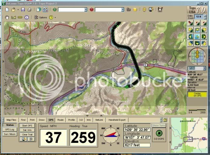
I have an older version of Delorme's Topo USA 5.0, which I had on my old laptop. It was exactly the program I need. But the old laptop died last year and I had to get a new one...with Windows Vista as the operating system...ugh. (I am guessing that some of you have seen this movie before and already know how it ends...). Unfortunately, Vista "does't do" Topo USA 5.0. I tried loading it last night...no go. After some Googling I discover that I am not alone and there is nothing to do but upgrade to the newer version, Topo USA 7.0. (I've seen some Vista problems with ver. 6.0 as well, though it works).

Does anyone have any experience with running 7.0 with a USB Earthmate receiver on the rails? Or is there any other topo software you would recommend? I don't want a handheld GPS at this point. I also have a Garmin nuvi 670 which should work, but certainly that would be a step back from even Street Atlas. It is the topo data (particularly 3-D) that I really want for this trip.
 
Chessie, I just took a trip and "monitored" the train's location with my Garmin c340 - nice, but it left a great deal to be desired. The idea of software on the computer hooked to a GPS that talks to the 'puter is great. Since I am an old fogy still running Windows XP, sounds like ver 5.0 would be sufficient. What hardware would I need?
 
I used an Earthmate LT20 with TopoUSA 7.0 on the Zephyr and it worked great. The tunnels confuse it a bit, but otherwise dead on.

It is nice to just have to carry the small antenna and nothing else. If your taking a laptop anyway, it is the way to go.

GPS2.jpg
 
Last edited by a moderator:
I used an Earthmate LT20 with TopoUSA 7.0 on the Zephyr and it worked great. The tunnels confuse it a bit, but otherwise dead on.It is nice to just have to carry the small antenna and nothing else. If your taking a laptop anyway, it is the way to go.

GPS2.jpg
Very cool screen shot. Has anyone tried the Earthmate LT-40 with the included Street Atlas USA? I see that the TopoUSA 7.0 is almost

$100 bucks, which is a bit pricey..... :) If so, did you have to do anything special to get it to work correctly?
 
I can get 2006 Microsoft Streets & trips w/GPS sensor for abut $40.

How would that be for on Amtrak use?
 
I've used DeLorme v 7.0 with XP with pretty good success. However, I used a GARMIN receiver hooked to my laptop as opposed to using an Earthmate. I realize that doesn't address your Vista question, but I thought it help you with understanding DeLorme v 7.0 performance.

I've become somewhat of a geek when it comes to tracking train travel via GPS, especially on the long haul trips. I think its interesting to monitor the trip, speed, distance, direction, etc.

Good luck and please let us know what software you end up using:)

Deimos
 
I have used both Microsoft Streets and Trips 2006 and Garmin on the Coast Starlight. Both have worked just fine.

I like the map a little better on the Microsoft program.

Gary
 
I have MS Streets & Trips along with its GPS and I love it. Before MS had a GPS unit available for Streets, I used the Delorme/Earthmate. It worked fine, but the software itself isn't as easy to use as Streets, so I was using Delorme when I wanted the GPS, and Streets when I was just looking up directions. I did upgrade to the Delorme TOPO and that was pretty cool, but still the same control issues.

I have since used the Streets and GPS in the car and even the plane! Now that was cool! "Driving" at 500 MPH and 30,000 feet is a trip. Plus, flying from Seattle to Minneapolis, I could tell by maps that we were flying right over the EB route for about half the flight.

If you are going through mountains, the Delorme (especially TOPO) might be interesting to view. Otherwise, the Streets is much easier to use. The bottom line is that either program will probably work fine, it's just personal preference between the two.

I have not yet had a chance to use Streets on the train yet, but I plan to this summer when we take EB to go to St. Paul/Glacier/Seattle/St. Paul. I can't wait until August! I want to go now!

Tuba-IA

A tuba is a terrible thing to waste.
 
Chessie, I just took a trip and "monitored" the train's location with my Garmin c340 - nice, but it left a great deal to be desired.
I tried to "monitor" the train's progress with my Garmin once, but had two problems. First, I could not get a continues clear shot of the satellites from my window. That resulted in a lot of "loss of signal" warnings. Second, every time we got near a road, it tried to force my location onto the road, instead of the tracks. It would try to hold onto the road, until I guess the position error got so bad, it had to move my current position back onto the track.
I had all those problems too, but I still enjoyed it.

We will be going from STL to KCI soon - I'll have my laptop with Delorme Earthmate LT-40 GPS Sensor, Delorme Street Atlas 2009 and I hope Delorme Topo 2005 on it.

Should be fun.

Again, you can get the LT-40 and Street Atlas 2009 from Fry's for $50 the $30 in rebates may or may not still be good - talk to Fry's about that.
 
I have since used the Streets and GPS in the car and even the plane! Now that was cool! "Driving" at 500 MPH and 30,000 feet is a trip. Plus, flying from Seattle to Minneapolis, I could tell by maps that we were flying right over the EB route for about half the flight. Tuba-IA

A tuba is a terrible thing to waste.
Aloha

From an IA to IA person I am reminding you that a GPS (radio) use on a plane is a violation of FAA regulations and it can affect the planes radio receivers. If you remember the pre-flight announcements, above 10,000 feet only non radio electronics are permited.

Mahalo
That is partially true. On most airlines, a GPS receiver it is permitted, since it does not transmit. In fact, I've entertained flight attendants with the tool by showing them where we were compared to landmarks. I've also talked to others who have used them, both on airlines and private planes.

LINK lists airlines that specifically allow or do not allow GPS during cruising. Luckily, all of the airlines I fly are on the Allow list.

Tuba-IA

A tuba is a terrible thing to waste.
 
That is partially true. On most airlines, a GPS receiver it is permitted, since it does not transmit. In fact, I've entertained flight attendants with the tool by showing them where we were compared to landmarks. I've also talked to others who have used them, both on airlines and private planes.
LINK lists airlines that specifically allow or do not allow GPS during cruising. Luckily, all of the airlines I fly are on the Allow list.

Tuba-IA

A tuba is a terrible thing to waste.
Mahalo for the update, and list, the Airline I will be on in July is on the list, However there hints page still list no gps use. Bureaucracy :lol: I also seem to remember that it was mentioned in the preflight announcement last November. I have printed the list
 
My wife and I took the Texas Eagle from Chicago to Temple TX a couple of weeks ago. I used my MS Streets and Trips to monitor the trip the whole way with no problem. I used the "Create GPS Trail" function to record the route as well. It held right on the rails the whole way. I have also used this program on planes with no problem. Next week we will be taking the Texas Eagle to Chicago and the City of new Orleans to Memphis. I will be doing the same on that trip as well. It really helps you keep track of where you are.
 
My wife and I took the Texas Eagle from Chicago to Temple TX a couple of weeks ago. I used my MS Streets and Trips to monitor the trip the whole way with no problem. I used the "Create GPS Trail" function to record the route as well. It held right on the rails the whole way. I have also used this program on planes with no problem. Next week we will be taking the Texas Eagle to Chicago and the City of new Orleans to Memphis. I will be doing the same on that trip as well. It really helps you keep track of where you are.
This is quite interesting, we're going x-country by rail in the fall, 4 days on the train each way. I see Amazon.com has Streets and Trips 2008 w/GPS for $64 shipped, I may do this. I was planning on taking the laptop anyway.

Dennis
 
Ok, Sreets and Trips with GPS got here today, and I installed it, threw the laptop in the pickup and drove around a bit out here in the country, and I'm just impressed I can do this for 65 bucks. It's going to make the rail journey that much more interesting.

Also, I used the program's route planning to plot driving about the same route that the train will take, factoring in gas mileage, how much we'd want to drive per day, rest stops, meals, motels etc. It would take a day longer to drive each way, and cost more than the Amtrak trip with Roomette booking.

Dennis
 
For non-laptop GPS, I've used a Mio 100 and it was great except the battery only lasted maybe 6 hours, then I had to take it back to the room. It had a "cross-country" setting that worked for trains, a setting so it would display tracks, and I put in all of the stations manually. Luckily I had all their addresses because the database in the Mio isn't very big. Different models of the Mio start around $100 or so.

I got good reception even in a downstairs room by propping it against the window at an angle so it faced out and up. This took some experimentation but then it was easy. The Mio's antenna is on the top.

I just got a cell phone with GPS software so am going to try that out the next trip. It doesn't show RR tracks and can't do multi-point routes, but will go cross country on a "follow-me" map setting. So I will be able to tell where I am relative to towns and what speed we are going, but not have any idea of time or distance just by looking because there is no scale. (Who ever heard of a map without a scale?!) Data transfer really eats up the battery so it will be interesting to see how long GPS holds out.
 
I was the 13th person in Alaska to get an iPhone 3G! :) The included Google Maps with A-GPS support is pretty cool.

Won't do turn-by-turn directions (will have to wait for the TomTom software to come out for that) and doesn't show speed, but for riding trains, it should work great for train rides, at least in areas with 3G or EDGE data service, since the Google Maps imagery usually shows train tracks.

Unfortunately, I don't have any Amtrak trips scheduled for the foreseeable feature (was hoping to do a NARP next fall, but it looks like I won't be able to, unless I can squeeze it in next September before it's discontinued...).
 
When I was a kid (60 years ago) my Dad gave me a pocket altimeter and showed me how to set it according to the current barometric pressure at each major point along the old CNR route from Toronto to Vancouver. So I was able to tell him just how high we were when we got off the train in Jasper to watch them add two more steam locomotives to pull us through the Rockies.

Now I'm about to take my first sleeper car train trip in 40 years, and be darned if I can find my altimeter! But my laptop will stay firmly at home, because for me, THIS trip will be about re-connnecting with the slower pace as I retire - eating, reading, sleeping, watching scenery, and talking with new-found friends.

All that said, if I see someone with a GPS, I'm sure going to ask if I can have a peek! :p
 
I have Microsoft streets and maps and am currently tracking the trip. South side of the train is better. I like the ability to put a trace on the map so I can tell the route. Very useful when you are specifically looking for some items and you know when you are at the desired point.

Stan
 
I have Microsoft streets and maps and am currently tracking the trip. South side of the train is better. I like the ability to put a trace on the map so I can tell the route. Very useful when you are specifically looking for some items and you know when you are at the desired point.
Stan
Stan

Which train are you on?

How are you finding internet access?

Dennis
 
Chessie, I just took a trip and "monitored" the train's location with my Garmin c340 - nice, but it left a great deal to be desired.
I tried to "monitor" the train's progress with my Garmin once, but had two problems. First, I could not get a continues clear shot of the satellites from my window. That resulted in a lot of "loss of signal" warnings. Second, every time we got near a road, it tried to force my location onto the road, instead of the tracks. It would try to hold onto the road, until I guess the position error got so bad, it had to move my current position back onto the track.
I found on my Garmin 360 you have to change to off road mode to track on the rails. It doesn't show the tracks unless your in the third or forth zoom in mode. Good luck.
 
I was able to use tomtom version 6 for pocket pc last year and it was fun to see where you were and how fast your going, works well in the observation car
 
Status
Not open for further replies.
Back
Top