You are using an out of date browser. It may not display this or other websites correctly.
You should upgrade or use an alternative browser.
You should upgrade or use an alternative browser.
Subway-Style Map of the Amtrak System
- Thread starter MrFSS
- Start date


Help Support Amtrak Unlimited Discussion Forum:
This site may earn a commission from merchant affiliate
links, including eBay, Amazon, and others.
- Status
- Not open for further replies.
All that link gets me is a flickr/Yahoo sign-in page.
the_traveler
Engineer
Me too!

I must get it as I am a Flickr member and was signed in when I found the link.All that link gets me is a flickr/Yahoo sign-in page.
Try this LINK and see if you can get it this way. If you can't you might have to join Flickr (we have an AU group on Flickr) and it is free.
Were you able to see it without being signed into Flickr?What a great map!
Cho Cho Charlie
Engineer
Me three.Me too!
 hboy:
hboy:And if you happen to have a Yahoo P/W, the very next step is that you then have to sign up for a new Flicker account! :help:
Cho Cho Charlie
Engineer
That only seems to get me the miniature thumbnail. :unsure:Try this LINK and see if you can get it this way.
Could someone please download this map, and post it somewhere better? :wub:
Last edited by a moderator:
Ryan
Court Jester

Click to go to the image at flickr where it can be embiggenated.
Embiggenated????
Click to go to the image at flickr where it can be embiggenated.

frugalist
Lead Service Attendant
What an absolutely cool map! A lot of talent and hard work obviously went into its creation. Thanks for sharing.
the_traveler
Engineer
is that the opposite of Disembiggenated? (I just want to make sure I'm using the correct meaning!)Embiggenated????Click to go to the image at flickr where it can be embiggenated.
Devil's Advocate
⠀⠀⠀
I tried, but the admin silently removed all traces of it without explanation. I'm assuming it's a copyright issue they're worried about, even though inline images that have so far been left alone can also result in complications with copyright. <_<Could someone please download this map, and post it somewhere better? :wub:
I tried, but the admin silently removed all traces of it without explanation. I'm assuming it's a copyright issue they're worried about, even though inline images that have so far been left alone can also result in complications with copyright.
Since you downloaded it an put it on another site, didn't feel comfortable with that. We had already fixed it so folks could see and get it from Flickr, so no need to have it from both places.
[/QUOTE]
Last edited by a moderator:
ALC Rail Writer
Engineer
Somebody actually labeled Alliance!
Last edited by a moderator:
L
LA Resident
Guest
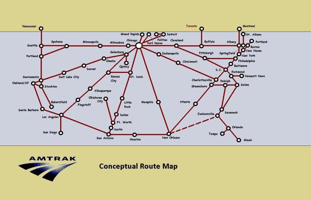
Pretty neat.This is from graphic designer Cameron Booth, who has designed several subway-style maps.
Different sizes are available for viewing or download.
Link
And the design really drives home the fact tha so much of Amtrak service is concentrated in the Northeast Corridor.
henryj
Conductor
Nice map. You should see if Amtrak will use it in their timetables and brochures.
DowneasterPassenger
Lead Service Attendant
Nice map, very detailed, and geometrically satisfying, but I still like my layout better. I haven't yet found time to work on an updated version of this based on suggestions I got here before, but the sense of urgency is growing.
Re: Embiggenated. Can someone help me smallify this pic?
Re: Embiggenated. Can someone help me smallify this pic?
Last edited by a moderator:
G
guest
Guest
I like the subway-style map much better. It is both informative and well-designed. Your map is too utilitarian; it reminds me of a map my third-grader could make. Sorry.Nice map, very detailed, and geometrically satisfying, but I still like my layout better. I haven't yet found time to work on an updated version of this based on suggestions I got here before, but the sense of urgency is growing.
Re: Embiggenated. Can someone help me smallify this pic?
ALC Rail Writer
Engineer
Actually I would argue the opposite is true-- look up the definition of "utilitarian". The Subway map, while more professional, is more pleasing to the eye and less practical. They're both good, but neither is really practical when it comes to Amtrak.
I would laugh if I saw some tourists holding the Subway-style map in CUS asking "where is the red-line, we want to get off in Denver" :lol:
I would laugh if I saw some tourists holding the Subway-style map in CUS asking "where is the red-line, we want to get off in Denver" :lol:
ALC Rail Writer
Engineer
A mild criticism of the Subway-style map... do the Regionals really go to Springfield? I was under the impression that for the regionals in NHV there was a corresponding shuttle, but no regional changes power at NHV to proceed to SPG... That would require having to park a regional consist in SPG.
Yes, it is an excellent map. Does a very nice job of showing the route of the trains and where they overlap. For example, makes it easy to see where the 2 Silver service trains go. Like the box showing all the trains lines ending in Chicago, while the bar for NYP has most trains start/stop there, but the NE Regionals & Acelas run through the station. This map would make a nice addition to the Amtrak website with embedded links to the station and route information pages.Nice map. You should see if Amtrak will use it in their timetables and brochures.
For fun, imagine the map a few years from now with new service to Madison WI, the 3C corridor in OH (if it happens), Downeaster extended to Brunswick, Vermonter rerouted to the knowledge corridor in MA, new Regional to Norfolk south of James River for the announced paid for changes. Then for the near term discusses possible/probable improvements: Lynchburger extended to Roanoke VA, Heartland Flyer to Kansas City, Silver service using the FEC in FL, what appears to be likely to get funded in the next HSR grant go-around Chicago to Iowa City, and for kicks, service restored FL to New Orleans.
Last edited by a moderator:
C
Cameron Booth
Guest
Hi, I'm the designer of the map... very interested to see such a lively discussion of my work here. In regards to this question, I've just checked the Northeast Regional timetable (because you made me paranoid about it, LOL!) and some Regionals definitely seem to travel to/from Springfield:A mild criticism of the Subway-style map... do the Regionals really go to Springfield? I was under the impression that for the regionals in NHV there was a corresponding shuttle, but no regional changes power at NHV to proceed to SPG... That would require having to park a regional consist in SPG.
#141 leaves Springfield at 6:00am M-F and goes to Washington, DC
#143 leaves Springfield at 6:30am Sat-Sun -> Washington, DC
#145 and #147 do similar... and there are Regionals that do the same Northbound as well: #136, #140, #148, #146. Interestingly, all the SB trains ar in the morning and all the NB trains are in the evening, so you may be right about the storage of trains at Springfield.
Cheers,
Cameron
Ryan
Court Jester
Hi Cameron, very glad to have you here!
I really like the WMATA map that you did as well - much better than what's currently out there.
I really like the WMATA map that you did as well - much better than what's currently out there.
- Status
- Not open for further replies.
Latest posts
-

-
-
-
-
NCDOT studies improving Amtrak service in NC
- Latest: McLeansvilleAppFan
-

-