Sights on the CZ route

Amtrak Unlimited Discussion Forum

Help Support Amtrak Unlimited Discussion Forum:

This site may earn a commission from merchant affiliate links, including eBay, Amazon, and others.
Status
Not open for further replies.
The eastbound lanes are cantilevered out over the Colorado river. The westbound lanes are on a viaduct several feet above the canyon floor.
USDOT usually prohibits bicycles along the IHS, but made provisions for them in Glenwood Canyon - likely as part of the settlement of one of the law suits.
For quite a while now there is a fantastic bike trail the whole length of the canyon. For a significant portion, the eastbound lane is cantilevered over the bike trail.
 
The descriptions everyone share reaffirms my belief we could build a wonderful travel guide for each of the routes,,,, but I am at a loss at what sort of software platform to build it on,,,,
 
Microsoft publisher

If you want, I could compile it for us.
 
Last edited by a moderator:
I had at first thought some sort of blog platform because I envision a tool that can accept contributions ,, but things like Google's blog tool are sequential, and unless you go in and reorder the dates (might be a considerable task) it wouldn't make sense....what would work would be a moderated world where contributions were made then compiled,,, start for example with that list of stops,,, break it into segments (states) then the moderator could paste the contributions in,,, with some sort of suggested guidelines for an entry,,, ill take a look at ampedia,,,, surely the collective genius of this group could make something like this work,, and consider the value for the traveler,,,
 
Westbound lanes of I-70 go throught that short tunnel. Eastbound lanes go around that rock outcrop next to the river.
 
Some other notable sights on the CZ route (in westbound order)

The CZ crosses the Mississippi river which is the border between Illinois and Iowa, so it's just before the Burlington, IA station.

The CZ crosses the Des Moines river just after the Ottumwa, IA station. (in daylight during daylight saving time).

(At night, unless the train is way off schedule)

The Missouri river (Iowa/Nebraska border) after/before Plattsmouth, NE

The Platte river and then Offut AFB between Plattsmouth and Omaha.

The CZ crosses the Platte River again after Omaha, between Gretna and Ashland, NE.

A few miles out of Holdrege, NE the CZ follows the Republican River into Colorado.

Beyond Denver/Arvada the sight seeing gets kinda busy:

The CZ starts climbing up into the Rocky Mountains and the first sight is the Big 10 Curve.

After the Big 10 Curve the tracks make a couple more 90° turns before the track makes a 180° switchback over Coal Creek Canyon Road with the Cool Creek Canyon to the left of the train.

At the end of the Coal Creek switchback is the 1st of 20 some tunnels in the next 25 or so miles.

Between the 1st and 2nd tunnels is an area called Plainview that offers a great view of the Denver/Boulder area.

Between the 16th and 17th tunnels we get to see South Boulder Canyon and the Gross Reservior Dam.

The 6.2 mile Moffat Tunnel is the main tunnel attraction at the end of the 25 mile miles of tunnels. Of course, the Moffat Tunnel is dark inside and we can't really see it.

At the west portal of the Moffat Tunnel is the Winter Park ski resort.

After Kremmling we go through Gore Canyon for 22 miles or so.

Further on we enter Red Canyon which can't be missed because of the red cliffs.

Not long after the CZ route joins I-70 at Dotsero.
 
I was just reading about the Rocky Flats Nuclear Weapons Plant and realized the site of the plant is just 2.25 miles north from the tracks the CZ uses on the approach to the Big 10 Curves, which start 3 miles further west.

Rocky Flats was shut down in 1992 after an FBI raid in 1989 confirmed reports of wrongdoing and EPA atomic materials regulation violations. All the building were torn down and the land is now a Super Fund clean up site.

The Big 10 Curve is at the lower left in this photo:
https://www.google.com/maps/place/Rocky+Flats+Nuclear+Weapons+Plant+Superfund+Cleanup+Site/@39.8660762,-105.2076422,8051m/data=!3m1!1e3!4m6!1m3!3m2!1s0x876b8deb2e9cefb5:0x3b3128dcd9e5807a!2sRocky+Flats+Nuclear+Weapons+Plant+Superfund+Cleanup+Site!3m1!1s0x876b8deb2e9cefb5:0x3b3128dcd9e5807a
 
Last edited by a moderator:
I just remembered another I-70 point of interest but in eastern Utah along a flat area (Sagers Flat) between the Book Cliffs and the train from about Cisco to Crescent Junction that is an area where there are quite a few bald eagles.
 
The drug store where Brad Pitt hit on Geena Davis in "Thelma & Louise" is located trackside in Thompson, UT.

Look quick. Track speed is 70 mph at this location.
 
Hastings, Nebraska is an early morning (1:45 am or so) stop, but you might want to offer a toast to Edwin Perkins.

Make your toast with Kool-Aid, which Mr. Perkins invented right there in lil 'ol Hastings.
 
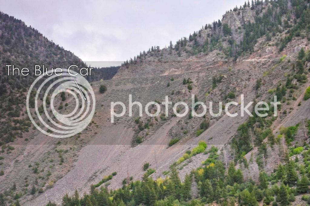
The blue car is west of Winter Park in the canyon near Azure. There is a dirt road up on the south side of that canyon that is quite drivable in summer months -- has great views of trains across the River.
Is that Trough Road (County 1) in upper Gore Canyon?

I can't find Azure on google maps.
 
The blue car is west of Winter Park in the canyon near Azure. There is a dirt road up on the south side of that canyon that is quite drivable in summer months -- has great views of trains across the River.
Is that Trough Road (County 1) in upper Gore Canyon?I can't find Azure on google maps.
Go to Bing Maps and type Azure Colorado. It's just basically a passing siding along the river on the UP's Moffat Subdivision
 
Last edited by a moderator:
Thanks.

Bing Maps shows Azure, but little else on that part of their map.

No road names, no road numbers, no landmark names.

But they had the Lat/Long so I copied that.

With the Lat/Long I confirmed on Google Maps that yes, the "blue car west of Winter Park in the canyon near Azure" is probably in Gore Canyon.
 
The east end of this gravel road is just south if Kremmling, off of state hwy 9. The west end of the gravel road is near State Bridge, CO off of state hwy 131.
 
I've been on that dirt road - my mom and I had spent time in WP* after dropping off my dad for a conference in Golden or Boulder and were heading on to Grand Junction. It was suggested by a local as having no passes, being shorter and no traffic, which was true. It was hot, dry and dusty (and we were in a brown car with no ac) and my mother wasn't too happy to be on that road, I was only like 12 so I couldn't help drive. Coming the other way we've gone up over the paved road with the campground(s) at the pass just north.

Another sight after Glenwood before GJ are the coal seam fires - I think there are several on both the north and south faces of the canyon. Maybe 40-50 miles east of Grand Junction.

*Winter Park
 
I've driven the roads parallel to the entire CZ route across Colorado, including the Rollins Pass 'Corona Road'....

I would like to see a shot of the former station at 'Bond' that the RGZ used to make between Granby and Glenwood Springs, but could find no photo's...

That could have been a neat 'stumper' on the 'What station is this' (whatever happened to that?) thread. I recall having lunch at the cafe in the crew hotel they had there for the freight train crews. There was a similar one at Minturn on the Tennessee Pass (Royal Gorge) line.
 
TheBlueCar1.jpg
 
Status
Not open for further replies.
Back
Top