Empire Connection Routing

Amtrak Unlimited Discussion Forum

Help Support Amtrak Unlimited Discussion Forum:

This site may earn a commission from merchant affiliate links, including eBay, Amazon, and others.

National Limited

Service Attendant
Joined
Jul 21, 2003
Messages
204
Location
Springfield, MO 65804
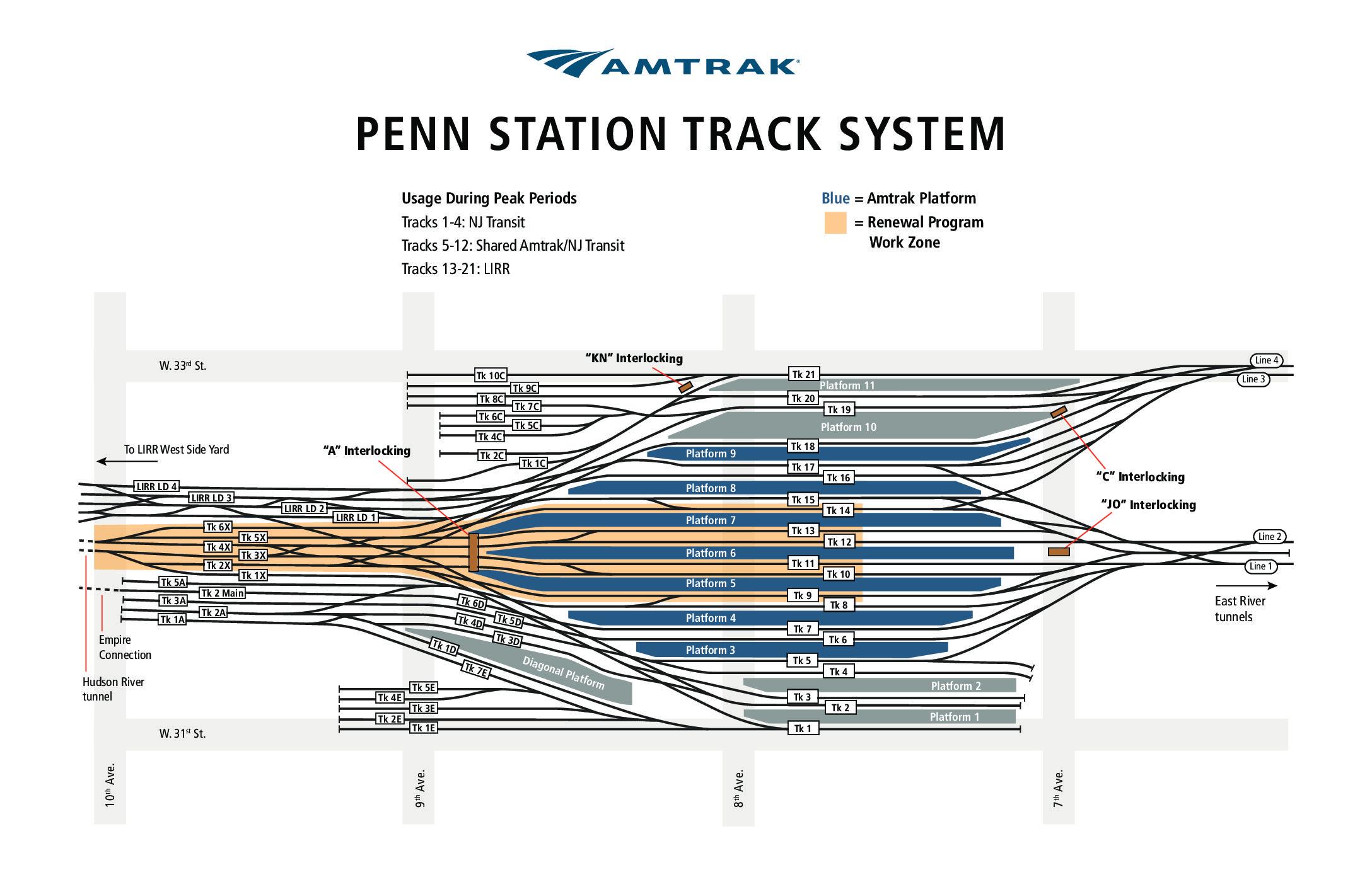
I recently had the opportunity to ride several Amtrak trains from NYP via the Empire Connection. I have done so on several other occasions over the past number of years. Each time I've tried to visually trace the exact routing of the trains out of or into NYP. As of yet I have failed to get my bearings and figure out how trains get from the west side line into the station--it's never dark enough in the cars to see out the windows and see where we're going.

So my question: Does the track of the Empire Connection go under the west side throat of of Penn Station? If not, how does the train get from the station to the westside line?
 
It also goes under the 8th Avenue subway line, and under the LIRR west side yard lead...pretty intricate engineering involved in all that...
Oh, almost forgot, it goes over the 7 line subway extension.
It connects with the former NYC west side freight line and uses it all the way up until it crosses the Harlem River into Bronx at Spuyten Duyvil, where it joins the Metro North Hudson line.
 
Last edited:
Wow! So headed west from the station it goes:

- Under the 8th ave subway line (which to me is a given)
- Under the LIRR west side yard
- Over the north river tunnels.

That is one fancy piece of engineering! Talk about threading the needle!

Two follow up questions:

1. At what street does it actually connect with the original NYC west side line?
2. Where are the portals to the north river tunnels--between 9th and 10th?
 
It passes over the North River tunnels before going below the LIRR west side yard lead (not the actual yard which is further west)...
 
I know there are several reasons why it can't happen but I often thought it was rather enticing that Superliners could probably get that close to NYP for the Lake Shore Limited since the freight line may have adequate clearance.
 
Wow! So headed west from the station it goes:

- Under the 8th ave subway line (which to me is a given)
- Under the LIRR west side yard
- Over the north river tunnels.
It goes under the east end of the LIRR Yard, east of 11th Ave. It is just below the yard tracks. The tunnel was built using cut and cover method before the LIRR yard trackage was built. Similarly the approach tunnel to connect to the new Hudson tubes has been built under the LIRR Yard upto 11th Ave., where presumably it will connect to bored tunnel, in this case actually digging up part of the yard, building the tunnel and then restoring the yard above it.

Yeah the 8th Ave subway thing is not really exclusive to the Empire Connection. 8th Ave passes over Penn Station platforms. The Moynihan Concourse on the west side of 8th Ave will have direct access to most platforms of Penn Station as does the current West Side Concourse on the west side of 8th Ave. All of Penn Station tracks pass under the 8th Ave subway, and that is two Aves away from the tunnel portals, both for North River and for Empire Connection, and eventually for the new Hudson tubes (Gateway Tunnels).
That is one fancy piece of engineering! Talk about threading the needle!
Well it is a well designed piece of engineering, but really not as complicated as it is being made to sound here.
Two follow up questions:

1. At what street does it actually connect with the original NYC west side line?
A little east of 11th Ave, around 35th St.
2. Where are the portals to the north river tunnels--between 9th and 10th?
At the west edge of 10th Ave. Here is a more or less accurate diagram of Penn Station:
penn-station-subway-map.jpg


BTW, Trains Mag had published a schematic diagram a while back which shows the position of the Empire Connection across the Hudson Yard way further to the west than it actually is. But hey! It is a schematic diagram and not an accurate geographical depiction.
 
I was just wandering around the area 2 weeks ago. I think it emerges from under 36th street between 10th and 11th Ave (closer to 11th.) It is a single track with both overhead catenary and third rail. It disappears again under a highway, the approach to the Lincoln Tunnel. I think I got a glimpse of it at 35th street, but there is a lot of construction (opaque plywood fences) in the area obstructing the view.
At the time it reaches 35th St, it is actually heading northeast, away from the Hudson, having turned more than 90 degrees after departing Penn Station, but it quickly bends back towards the north. I never found where it finally emerges; Manhattan is LONG when you are on foot!
 
Yes. It’s a single track through the tunnel with overhead and third rail. The third rail is what’s mainly used. The overhead is used by a motor if that’s what PSCC assigns to rescue a stalled train. That is CP EMPIRE. It goes from one to two tracks there.
 
In addition to the good map above, there are others that show less detail but more of the path of the connecting track.


View attachment 14628

There was also a decent cab video shot from an FL9 shortly after it opened - Pentrex IIRC.

That is the diagram showing an incorrect geographical depiction of the path that I mentioned previously [emoji6]

Entering the Empire Connection tunnel at 10th Ave, first it turns left (southwards for a bit, and then makes a long right turn until it is facing almost northeast to emerge at 35th St. The entire turn happens between the 10th and 11th Ave.
 
Last edited:
Yes. It’s a single track through the tunnel with overhead and third rail. The third rail is what’s mainly used. The overhead is used by a motor if that’s what PSCC assigns to rescue a stalled train. That is CP EMPIRE. It goes from one to two tracks there.

I believe CP Empire is around 40th St. or thereabouts. There is also a strange wye a little north of CP Empire. I have no idea who would use it for what. Doesn’t look like it has seen much use, if any at all.
 
The "wye" is a remnant of the original route to the High Line, if I remember correctly. If you look at the overhead satellite view in Google Maps, you can see the original NY Central route between 10th and 11th Avenue from 36th to 49th, after which it disappears from sight. I've never been quite sure where the newly-built-for-Amtrak Empire Connection tunnel diverges from the original route, but I think it's actually way down between 34th and 35th St.

Google Maps (map view, not satellite view) actually has a very faint line tracing the entire route. If you're careful you can follow it from 49th Street to and through Riverside Park, which is completely invisible from the surface. It starts curving west at 53rd Street and passes just to the east of the IRT Powerhouse; under PS191; runs between Riverside Drive and Freedom Place; and then runs under the park (whree the line is pretty visible on Google Maps). I wouldn't bet on it being perfect but it is very close for the parts I've been able to verify. It indicates that south of 35th Street, the tunnel may swing west of 11th Avenue, tnough not by much.
 
Last edited:
Along the way, you can usually catch a glimpse of the tracks from almost any cross street...there are many buildings along the way built using air rights over the tracks. One place to catch a glimpse I often see, is at 41st Street and Galvin Avenue (aka Father Stepinac Place), which is actually a block long bridge over the railroad connecting 41st and 40th street, and the entrance to the Lincoln Tunnel north tube..

Several of the cross streets have gates, and ramps for MOW and RR Police vehicles to access the ROW.
 
Back
Top