Sunset Limited ~ best side for views and consist - eastbound

Amtrak Unlimited Discussion Forum

Help Support Amtrak Unlimited Discussion Forum:

This site may earn a commission from merchant affiliate links, including eBay, Amazon, and others.
Status
Not open for further replies.

user 6862

Engineer
Joined
Jun 18, 2009
Messages
2,201
Just booked a roomette on the Sunset Limited from Los Angeles to New Orleans for the 3rd week of March 2017, where in the consist is the car and which direction does the car face please? Have the Amtrak Superliner diagram to study and see that we are on the upper level which we want but would like to know which side it will be.

We're particularly interested in seeing the deserts after LA from a high level train and also Louisiana.

Here's the ticket details - Superliner Roomette - Car 0230 - Room 005

Thank you
 
The sleepers should be at the front of the consist behind the baggage car, but you will be in the last one before the diner. There is no way of knowing which way you will be facing in advance, that is only possible in Viewliners. However, if there is one side you prefer to be seated on you can spend time in the lounge car, two cars behind your sleeper. Even if you are looking out the same side, I highly recommend spending a lot of time in the lounge.
 
Which direction does the car face please? Have the Amtrak Superliner diagram to study and see that we are on the upper level which we want but would like to know which side it will be.
So would many other travelers. Unfortunately Amtrak doesn't allow you to book a specific side or allow you to know in advance which side you'll be on before the train arrives, at which point it will be too late to change anything. You could book the Family Room, which has views of both sides, but you'll have to pay more and you'll be stuck on the lower level with tiny windows. If Amtrak randomly puts you on the side you don't want your best bet is to leave your roomette and visit the top level of the snack car during the important bits.
 
I can only speak as to three eastbound trips in the 422 sleeper at the rear of the train. All three times that particular sleeper (Texas Eagle) has been positioned so the bedrooms were on the right (south) side of the train. Just before arriving in ELP the Mexican Border is on that side.

You will be in darkness upon departing LA and until just before Maricopa. Not much to see until then.
 
Last edited by a moderator:
Hi,

I have only taken the Sunset eastbound on one occasion, when it ran all the way through to Orlando. (We arrived a whole day late into Orlando) !

Westbound I have taken it several times, roomettes used to be very reasonably priced compared to westbound northern routes.

I have to say that it is not a great route for scenery, apart from a few highlights. Dunno if the views to the south will be impaired by Mr. Trump's new wall construction by February... :p

Have a great trip,

Ed.
 
Last edited by a moderator:
First a happy Christmas and thank you for all the info, I've got the picture now.

Ed, beauty is in the eye of the beholder, we've just spent over a week in Oklahoma and loved it! The prairie, the hills and the rugged panhandle are all beautiful to us, but even more so the people of the mid west.

Just passed on your India blogs to a school friend of mine, he's off to India in about 6 weeks time for a 4 week stay. He too is travelling alone as you do but has never been to India before. He did write to say that you have inspired him...

This next journey will total about 13 - 14,000 kms by train in quite a few countries, expect the differences between them all will be vast.
 
Lots of different terrain to view along that route from both sides of the train. Their will be a route guide in your roomette or in the lounge that will point out places of intrest. Enjoy the train and New Orleans, I can't wait to take the trip again.
 
Anyone know where the SL gets nearest to the Mexican border so we can see the new wall?
 
Last edited by a moderator:
Anyone know where the SL gets nearest to the Mexican border so we can see the new wall?
When you arrive downtown at the El Paso Station you will be very close to the border. ( the Rio Grande River which is a cement cesspool )
Before the train arrives into El Paso you will roll alongside the border fence ( right side) and can see Juarez about 100 yards away including the River,Roads and People's Houses. This will continue for about 20 minutes once you cross into Texas/El Paso from New Mexico.

You will see lots of Green and White Border Patrol Vehicles along the Fence, and if you use your Cell Phone your liable to pick up a Mexico Tower and be charged for Roaming at a Pricey rate!

You may also see the Border Patrol and other LE types at the El Paso Station and also aboard the train.

Don't count on seeing a "Wall", our President elect is known for telling whoppers and then denying he ever said them!
 
Last edited by a moderator:
There are interesting sights on both sides.
Note that the Sunset Limited/Texas Eagle goes through a part of the southwestern US that features Basin and Range topography.

As long as the train is on time sunrise will be at the same time your train is leaving Maricopa, AZ.
You will be in the Sonoran Desert until you get east of Benson, AZ.
A little over 25 miles out of Maricopa the train will go under Interstate 10 and stay fairly close to I-10 for most of the day.

Twenty miles further Picacho Peak (3400 ft) & State Park will be on the right. If they have a good rainy winter there will be lots of wildflowers in mid-March.
During the Civil War the Battle of Picacho was fought there on April 15, 1862.
There's a small flat spot on top of the peak that can be reached via two trails. Parts of each trail are precarious so cables and catwalks got added at some point for hikers trying the trails. That makes the trails 2 of the few via ferrata in the United States.

Out the left side of the train the you will see the Tortolita Mountains and the much higher north facing slopes of the Santa Catalina Mountains.
Mount Lemmon (9157 ft) is the highest point and has a small ski area that is the southern most ski area in the US and gets an average of 180 inches of snow over winter.
Back in the day the military had RADARs on top of Mt. Lemmon used to watch for Russian nuke bombers approaching the US from the south.
Now that area is the Mt. Lemmon Sky Center having many telescopes owned and operated by the University of Arizona and the University of Minnesota.
The main project, the Catalina Sky Survey, is a project to discover comets and asteroids, and to search for near-Earth objects (NEOs) that may pose a threat of impact with Earth.

Tucson is in a basin surrounded by the Tucson Mountains to the west, the Rincon Mountains to the east, the Santa Catalina Mountains to the north, and the Santa Rita Mountains to the south.
The Tucson and Rincon mountains are the 2 sections of Saguaro National Park, part of the National Park System.
The park preserves the desert landscape, fauna and flora contained within the two park sections. The park was primarily established to protect its namesake—the giant Saguaro Cactus that in this park are near the northernmost limit of their natural survival zone.

Tucson is a service stop and the train will be there for about 45 minutes. Across the street is the historic Hotel Congress and the Southern Arizona Transportation Museum is also on the train station grounds. Out the right side of the train you can see "A" Mountain.

Eight miles or so after leaving Tucson and on the left side of the train will be the Pima Air & Space Museum.
Some 22 miles out of Tucson you'll enter the Cienaga Creek riparian forest area, if the dispatcher has put the train on the more easterly tracks that go along Cienaga Creek.
The 2 sets of tracks split some 6 miles before the train can get to Cienaga Creek.

At that point, weather permitting, you should be able to see the white enclosure of the Whipple Observatory on top of Mt. Hopkins in the Santa Rita mountains south of Tucson.
Either way, some 8 miles beyond the split the 2 sets of tracks cross each other with the east set of tracks that go through the riparian area going under the west tracks.The 2 sets of tracks get together again near the small town of Mescal, AZ.

Out of the stop in Benson the train starts climbing to negotiate the pass in Texas Canyon.
The Little Dragoon Mountains (and I-10) will be on the left with the Dragoon Mountains on the right near the pass.
Cochise and his men were driven into the Dragoon Mountains in the late 1860s, They used the mountains to evaded capture and as a base to continue attacks against white settlements until a peace treaty with the Army was made in late 1872.

Once over the pass you'll drop down into the Basin surrounded by the Dragoon Mountains behind you, the Chiricahua Mountains to the East and the Pinaleno Mountains to the north.

The train will re-join I-10 at Willcox and be near I-10 all the way to Akela, NM where the train will veer off to the southeast, cross under I-10 and head more directly for El Paso.

The highest peak in the Pinaleno's is Mt. Graham (10,725 feet) another location of major astronomical telescopes. The Large Binocular Telescope's white enclosure should be visible out the left side of the train.

Some 24 miles past Akela the train goes by the Arden Lava Flow that will be out the right side of the train.

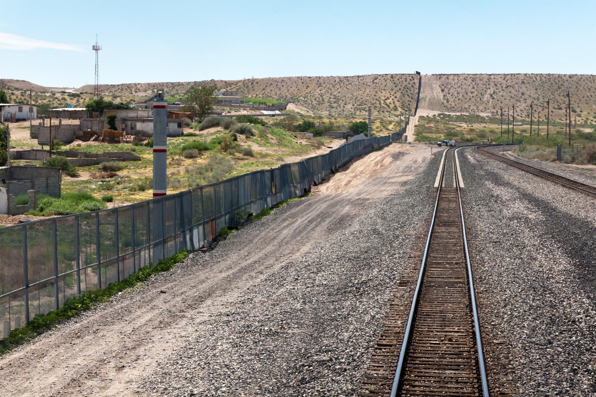
Some 20 miles further the SL/TE goes through the new UP inter-modal yard near Santa Teresa, NM.

Twelve and a 1/2 miles further the train gets as close to the border with Mexico as it gets on the right side of the train.

When the train crosses the Rio Grande River 2.5 or so miles later it's then in Texas, and if on time it's mid-afternoon.
 
As usual this forum has already made our SL journey more interesting, vivid descriptions, references, a superb photo of the exact spot of proximity to Mexico and a master class in describing the land that we will travel through.

For my part the interest is, will the wall get built and what will it be like. It's mainly due to having got close to and travelling through the Berlin Wall from the late 1960's through to and after it's removal and the current line built into the pavings and road ways to show exactly where it used to be. I lived in what was West Germany and visited good friends there often. I heard stories from Berliners that were heroic and tragic and thank goodness it only lasted about 30 years even with the most ruthless efforts of the Stasi.

It's not a comment on American politics as there is obviously a problem on this border and proper solution has to be found (and we have our own dire problems with Brexit to worry about anyway), but a real live huge wall represents something more than a border, more like a prison and at that point you ask who is inside and who is outside.

So my interest is due to Berlin, sorry if my comments offend as I have no intention of offending anybody on this forum.
 
Last edited by a moderator:
Most likely, the wall will never be built. The terrain is not conducive and USA does not have trillions of $$ to build such wall. And NO, MEXICO WILL NOT PAY FOR THE WALL.
 
I have seen migrants wading across the Rio Grande (border) from the Sunset Limited, and a little while later we saw a Border Patrol helicopter.

I think the best views of scenery are from the lounge car, so I would advise you to go there for the stretch of the trip that runs right next to the border. But other than the Rio Grande, the scenery is about equal on both sides of the train so I would not be too concerned about which side your room is on.
 
I too find it ironic that the Land of the Free and the Home of the Brave is considering building a Prison Wall along our Southern Border, especially when the 911 Maniacs that flew the planes into the World Trade Towers came into the country across the Northern Border from Canada!

"..Mr.Gorbachov, tear down that wall!"--Ronald Reaga/40th President of the US
 
Here's what Google Earth tells me about the closest track to Mexico:

Mexican Border.jpg

But, as I understand things, you could might be routed on the track a bit farther away.
 
Best to turn off roaming on your cell phone when around El Paso to avoid the signal hijack.
 
Status
Not open for further replies.
Back
Top