Sights on the CZ route

Amtrak Unlimited Discussion Forum

Help Support Amtrak Unlimited Discussion Forum:

This site may earn a commission from merchant affiliate links, including eBay, Amazon, and others.
Status
Not open for further replies.

KmH

Engineer
Joined
Dec 6, 2014
Messages
2,055
Location
Is this heaven? No. It's Iowa.
Back in the day I drove an over-the-road 18 wheeler.

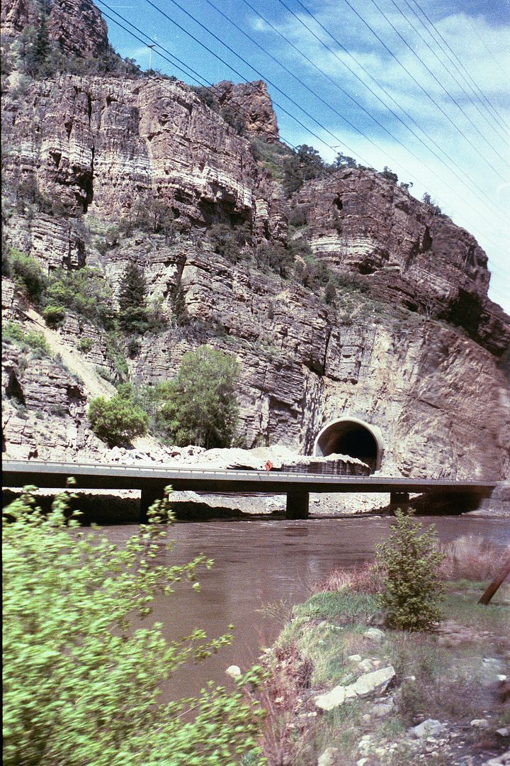
For me, one of the most beautiful sections of the Interstate Highway System (IHS) was going through Glenwood Canyon. On occasion I saw trains going by on the other side of the canyon.

Back then I learned a bit about the story of how that section of I-70 became one of the per mile most expensive rural highways ever built in the USA.

When the IHS was being planned, Denver was to be the terminus of I-70. Colorado's governor at that time, Edwin C. Johnson, lobbied to have I-70 continue west from Denver.

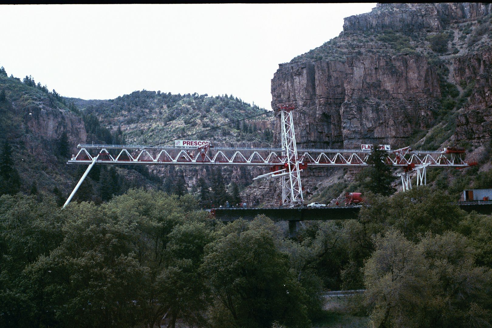
Construction of the 12-miles of I-70 through Glenwood Canyon was delayed by several law suits filed regarding the impact building the road would have on Glenwood Canyon and it's natural beauty. The law suits delayed completion of that section of I-70 long enough that the Federal Highway Administration claims that 12-mile section of the IHS was the last of the originally planned IHS to be completed.

The highway through Glenwood Canyon was completed in 1992.

The highway is on the north side of the Colorado river.

In the 12 miles there are 40 bridges, several viaducts, several tunnels, and miles of retaining walls.

The eastbound lanes are cantilevered out over the Colorado river. The westbound lanes are on a viaduct several feet above the canyon floor.

USDOT usually prohibits bicycles along the IHS, but made provisions for them in Glenwood Canyon - likely as part of the settlement of one of the law suits.

The train tracks, back then owned by the Denver and Rio Grande Western Railroad, are on the south side of the river.

Unseen is a command center staffed with emergency response vehicles and tow trucks that are always on standby.

Cameras along the viaducts and in the tunnels are monitored by command center staff so a quick response can be made if there is an accident.

The Glenwood Canyon section of I-70 has a reduced speed limit and there are traffic signals and variable message boards (equipped with radar guns) that can be used in case of an incident.

Since becoming interested in trains I've learned:

Five miles east of the head of Glenwood Canyon at the confluence of the Colorado River and the Eagle River is where the CZ route departs I-70 for a while and heads north up into the Rockies.

There is a small town there called Dotsero.

Ferdinand Hayden did an extensive survey of southwestern and central Colorado and published the results in 1877.

Hayden used the location of the confluence of the Colorado River and the Eagle River as his "Dot Zero" (reference point) for his survey maps.

Dot Zero became Dotsero.

Dotsero was an important railroad junction back in the day, and is located at the southern end of the Dotsero Cutoff then of the Denver and Rio Grande Western Railroad. Apparently, the part of the junction that runs east from Dotsero over Tennessee Pass is dormant.

The northern end of the cutoff was named Orestod (near Bond, CO), which is Dotsero spelled backwards.

A standard gauge railroad line was built from Dotsero to Glenwood Springs in 1890.

Dotsero is at the base of Colorado's most recently active volcano. According to the US Geological Survey the volcano last erupted 4140 years ago.

Add any other CZ sight info to the thread you think may be of interest to pax traveling on the CZ.

Here is some more info - http://www.fhwa.dot.gov/publications/publicroads/04mar/04.cfm
 
Last edited by a moderator:
Great post. Am taking the CZ in mid-march. Printed a copy of your post to take along with me to slip into the guide to make the trip even more interesting and enjoyable--when is your next class??
 
Thanks for the post. Having ridden the California Zephyr through Glenwood Canyon several times and observing the highway, I decided to do a road trip from Tennessee to Colorado in August 2013 just to travel on this I-70 through Glenwood Canyon. Actually stayed in Rifle, CO, between Glenwood Springs and Grand Junction and then came back to visit GS one day. Now I'm planning to travel this coming May on the CZ to Glenwood Springs and stay a couple days in the Hotel Denver in Glenwood Springs before leaving again on the CZ. Your history lesson was appreciated. I appreciated your information regarding the Federal Highway Administration since I worked as auditor for the Federal Highway Administration 1965-1980. Of course it was the Bureau of Public Roads in the US Dept of Commerce when I began but the big project was the constructing of the Interstate Highway System with a supposedly completion date of 1972 - some 20 years before I-70 in Glenwood Springs was opened.
 
Last edited by a moderator:
When both the eastbound and westbound trains are on time (and sometimes when both are late), they meet a few miles east of Glenwood Canyon.

Right near the old Hotel Denver is the world's largest hot spring fed swimming pool. I did see someone swimming in it in December 2013. I observed this while I was on board the westbound CZ sitting at the Glenwood station.

I'll be on the CZ eastbound on St. Patrick's day.
 
The Interstate highway project through Glenwood Canyon took great pains and expense to avoid major excavation, resulting in long elevated viaducts to carry the separate lanes. This provides drivers with sweeping views from above river level, enhancing the driving experience. Unfortunately, all those design features act to make the highway very prominent from the RR tracks. Those who remember the old two-lane riverside US. 6 road may be shocked to see what's there now, outside the north windows of the SSL. I guess you have to look at it as engineering achievement in a no-longer-so-natural setting.
 
Here is a photo I took on 14 January from the I-70 rest area at No Name, Colorado of the eastbound CZ. This rest area is about 5 miles east of the Glenwoods Springs Amtrak station.ImageUploadedByAmtrak Forum1421471080.876962.jpg
 
Great post and history lesson!

I would like to add a bit....For many years, at the Grizzly Creek siding in Glenwood Canyon where the east and westbound California Zephyrs would meet, stood a beautiful model of a Vista Dome car on a rock base, with plaques telling of its historic significance.....

It seems that during World War II, top General Motor's vice president Cyrus Osbourne was riding in the cab of a new Electro-Motive diesel locomotive on an inspection trip, when he told his host D&RGW people that passenger's would pay a fortune to ride up here, if they could see the view he was seeing of the Rockies.

Later that night, while at the Hotel Utah in SLC, he sketched a rough outline of a dome-topped coach, and submitted it to railroad executives for their consideration...

A few years later, the dome car was born...first from a converted Burlington Budd Coach, and later by GM's Train of Tomorrow, and many other's.

The model was named: "Monument To An Idea", and after being vandalized for years, was safely moved to its new home at the Colorado Railroad Museum in Golden, and restored...... http://en.wikipedia.org/wiki/Dome_car#mediaviewer/File:Glenwood_Canyon_monument_at_Colorado_Railroad_Museum.jpg
 
Last edited by a moderator:
The Moffat Tunnel, Gross Reservoir, and Gross Reservoir Dam.

The Moffat Tunnel was cut under a shoulder of James Peak to eliminated a series of switchback loops, several steep 4% grades, and the severe snow conditions encountered on the original tracks where they went over the Continental Divide at Rollins Pass (elevation 11,676 feet).

Much of the original, before the Moffat Tunnel, right-of-way is still intact although some of the trestles have collapsed. We can see parts of the old route on Google Earth or Google Maps satellite view.

A small wye on the passing siding (on the north side of the main line) at the eastern portal of the Moffat Tunnel marks the spot where the Rollins Pass line would have merged into the modern route if the route over Rollins Pass still existed. The wye is still occasionally utilized.

The Moffat Tunnel is named after the tunnel's brainchild, a Denver banker - David Moffat.

In 1902 David Moffat and others started the Denver, Northwestern, and Pacific Railway after Denver was bypassed by the Union Pacific Railroad and the Denver and Rio Grande Western Railroad.

Known as the Moffat Road the intent was to have a rail route from Denver to Salt Lake City.

[SIZE=14.3999996185303px]The 23 mile section over Rollins Pass was a [/SIZE]financial[SIZE=14.3999996185303px] burden due to the costs of clearing snow in the winter even though long sections of the track had snow sheds.[/SIZE]

[SIZE=14.3999996185303px]So David Moffat came up with the idea to tunnel under the Continental Divide.[/SIZE]

[SIZE=14.3999996185303px]David Moffat died in 1911 at the age of 73 and had been unsuccessful at raising the funds needed to start construction of the tunnel.[/SIZE]

[SIZE=14.3999996185303px]Others continued to champion the tunnel and a Denver bond issue was approved in 1914 that got [/SIZE]construction[SIZE=14.3999996185303px] of the tunnel started.[/SIZE]

There are actually 2 tunnels.

An 8 foot by 8 foot pioneer tunnel used to aid construction of the main tunnel was bored parallel to the railway tunnel. The pioneer tunnel was holed through with dynamite on February 18, 1926 with the push of a button in Washington DC by President Calvin Coolidge during a radio broadcast from the tunnel. After the railway tunnel was completed the pioneer tunnel was converted to a water tunnel.

The railroad tunnel was 'holed' through on July 7, 1927, and formally turned over to the lessee, the city of Denver, on February 26, 1928.

[SIZE=14.3999996185303px]​It took 48 months to bore the 6.2 mile [/SIZE]railroad[SIZE=14.3999996185303px] tunnel.[/SIZE]

[SIZE=14.3999996185303px]The apex of the tunnel is 9239 feet above sea level.[/SIZE]

[SIZE=14.3999996185303px]During the 5 years of construction, 28 people working on the 2 tunnels died, [/SIZE]six in a single cave-in on July 30, 1926.

By comparison to the Rollins Pass route's 4% grades, the grade in the Moffat Tunnel is 0.8%.

The original cost estimate was $6.62 million, but the 2 tunnels wound up costing $15.6 million, or $475 per foot.

The water that flows out through the east end of the 8' x 8' Moffat water tunnel becomes South Boulder Creek which flows to and is stored/regulated in the Gross Reservoir behind the Gross Reservoir Dam that was completed in 1954 and can be seen from the train.

The reservoir has a surface area of 440 acres.

Gross Reservoir Dam is 340 feet high and it's spillway is 7225 feet above sea level.

Gross Reservoir provides recreational opportunities though with restrictions.

[SIZE=14.3999996185303px]​Swimming and wading are not allowed. Boats used on the [/SIZE]reservoir[SIZE=14.3999996185303px] must be non-powered and must be the kind of boat that can be transported on top of a car.[/SIZE]

[SIZE=14.3999996185303px]If approved, Denver Water is planning to triple the [/SIZE]reservoir[SIZE=14.3999996185303px] [/SIZE]storage capacity.
 
Last edited by a moderator:
Great stuff! For several years, they maintained a semblance of a highway over the former Rollins Pass ROW, including single lane trestle's, tunnel's, and switchbacks for the adventurous to drive over. They even had a brochure at each end with a self-guided tour with mile-by-mile route description and points of interest. I drove it in 1974, and still have the brochure somewhere in my 'archives'.....

If anyone ever gets the chance, check out the silent classic film melodrama "The White Desert", set on that location, but perhaps filmed elsewhere (see comment in review)

http://www.imdb.com/title/tt0016523/
 
The Colorado River.

La Poudre Pass (10,184 feet) is a broad, flat, swampy area that straddles the Continental Divide about 35 miles north of the Amtrak stop at Granby, CO.

That part of the broad, flat, swampy area that is just west of the Continental Divide is where the Colorado River starts as a tiny stream.

2 miles west of the Granby station the tracks cross the Fraser River which joins the nascent Colorado River just 1/4 of a mile downstream (north) from the train tracks.

Another 1/2 mile west the train goes by Windy Gap Reservoir which stores some of the Colorado River before it continues down through the sparsely populated Western Slope of Colorado.

The Zephyr first runs by the Colorado there at Windy Gap reservoir and will essentially follow the course of the river about 225 miles between there to about 5 miles into Utah.

On it's descent down the Western Slope and through the Grand Valley other rivers, creeks, and streams join the Colorado River - the already mentioned Fraser River (near Granby), the Blue River (near Kremmerling), the Eagle River (at Dotsero), the Roaring Fork River (at Glenwood Springs), the Gunnison River (at Grand Junction), with the last on the Zephyr route being the Little Dolores River joining the Colorado in Utah near the Utah/Colorado border.

Most of the upper river seen from the train is a swift whitewater stream usually 200 to 500 feet wide with depth ranging from 65 feet to 30 feet.

About 70 miles west of Glenwood Springs at the west end of De Beque Canyon the Colorado River leaves the Western Slope and enters the extended populated major farming and ranching area known as the Grand Valley.

In De Beque Canyon the Zephyr passes the Grand Valley Diversion Dam, a 14 foot high, 546 foot wide concrete roller dam with 6 gates and a movable crest. The dam was built between 1913 and 1916.

The dam diverts some Colorado River water into 4 canals that stretch about 90 miles through the region so the water can be used to irrigate the Grand Valley. The main canal is the Government Highline Canal that is 55 miles long. The canals provide irrigation for 50,000 acres in the Grand Valley. The Grand Valley Diversion Dam was added to the National Registry of Historic Places in 1991.

West of Grand Junction and after going through Mack, CO the Zephyr re-joins and follows the Colorado River through the roughly 25 mile long Ruby Canyon into Utah. The main attraction in Ruby Canyon is where[SIZE=14.3999996185303px] the words "Utah | Colorado" are painted on the canyon wall at the border between the two states next to the Utaline siding. About 4 miles further west of the border the Zephyr route and the [/SIZE]Colorado[SIZE=14.3999996185303px] River diverge and go their separate ways.[/SIZE]
 
I thought the main attractions in Ruby Canyon were the landing spots along the river for whitewater rafters, where the rafters invariably greet the passing CZs with the "Amtrak Salute"?
 
I rode the CZ for the first time last September, the 5 to Emeryville and 10 days later, the 6 back to Colorado. On both trips someone (I presume the conductor but I don't know for sure) did a running commentary from the Big Ten almost to Glenwood Springs (and the reverse on the way back). Most of what was pointed out I was able to see (I wasn't in the observation car) but I missed this blue car or truck that had gone off the road and a bit down the mountain somewhere (If I recall correctly) east of Winter Park. I asked some other pax if they had seen it and they said they had but no one had taken a photo of it. Supposedly the occupants of this vehicle survived the accident...
 
The blue car is west of Winter Park in the canyon near Azure. There is a dirt road up on the south side of that canyon that is quite drivable in summer months -- has great views of trains across the River.
 
Thanks, chakk!

BTW I had to laugh when I saw your rest area photo; 25 years ago I took a photo of the same train from the same rest area, the only difference being that I took mine in late summer. So in September I got a shot of the rest area from the train! Didn't turn out that well unfortunately.
 
Thanks for all the history on I-70 KmH You should be a volunteer on the CZ doing audio in the Sightseer Lounge :) I'm going to be riding #5 next weekend from Denver to Sacramento and will be looking more closely along the route now.
 
I already have a 7-day a week, 12 noon to 4 pm summer job telling visitors the history of the Edel Blacksmith Shop in Haverhill, IA.

This summer will be my 5th season doing that.

Fortunately I know Matthew Edel's grand daughter and she has told me wonderful stories of growing up in Haverhill when Haverhill still had a Chicago, Milwaukee, St. Paul, and Pacific Railroad (The Milwaukee Road) depot. The trains last went through Haverhill in 1980 and the tracks were shortly thereafter removed and moved elsewhere.

Many of the more spectacular 'sights' on the CZ are in Colorado because the route is timed to go through there during daylight hours.

The 'Amtrak Salute' can be given anywhere along any of the train routes.

Winter Park is right at and just south of the west portal of the Moffat Tunnel, so east of Winter Park the CZ is in the tunnel for 6.2 miles.
 
Last edited by a moderator:
Great post and history lesson!

I would like to add a bit....For many years, at the Grizzly Creek siding in Glenwood Canyon where the east and westbound California Zephyrs would meet, stood a beautiful model of a Vista Dome car on a rock base, with plaques telling of its historic significance.....

It seems that during World War II, top General Motor's vice president Cyrus Osbourne was riding in the cab of a new Electro-Motive diesel locomotive on an inspection trip, when he told his host D&RGW people that passenger's would pay a fortune to ride up here, if they could see the view he was seeing of the Rockies.

Later that night, while at the Hotel Utah in SLC, he sketched a rough outline of a dome-topped coach, and submitted it to railroad executives for their consideration...

A few years later, the dome car was born...first from a converted Burlington Budd Coach, and later by GM's Train of Tomorrow, and many other's.

The model was named: "Monument To An Idea", and after being vandalized for years, was safely moved to its new home at the Colorado Railroad Museum in Golden, and restored...... http://en.wikipedia.org/wiki/Dome_car#mediaviewer/File:Glenwood_Canyon_monument_at_Colorado_Railroad_Museum.jpg
Thanks for this information!

I was on a coast to coast road trip in the summer of 1971 and we went through Glenwood Canyon, stopping at this monument. It seemed the perfect tribute to the most perfect passenger car in the perfect location. One of the highlights of the trip for me. The next time I was on that section of road was while I-70 was being built and I wondered what had become of the monument. I'm glad to hear it found a good home, though it is a shame people can no longer experience what I experienced the first, and only, time I saw it.
 
As a child in the 50's and 60's , we would leave Oak Park and go to Glenwood Springs on the Old Zephyr and take a room at the Springs Hotel - forgive me for not remembering the name.. Father would do his Nordic thing of leaving the hot spring pool, go rolling in the three foot snow drifts next to it and then jump back into the spring pool. We only stayed one night and would come back on the train the next day. My fondest memory was the splendid meals with china and silver and marvelous dining car staff who treated this child as though he were a king. I look forward to reliving at least part of this thrill this summer when we go to Yellowstone on the CZ albeit sans -snow and realize I will be lucky to have Amware instead of plastic. I just hope the RR toast is on the menu.
 
Here's a photo I took from the train of the construction on I-70 near Glenwood Springs in 1989

002_zpsf4813907.jpg


001_zps512ba67a.jpg
 
Last edited by a moderator:
The Great Plains.

The Great Plains are the western part of North America's Interior Plains.

The narrow sliver of the Great Plains we can see along the route of the California Zephyr can be further subdivided into 3 approximate regions:

1. The tall-grass prairies - Chicago to the Missouri river.

2. The mid-grass prairies - Missouri river to western Nebraska.

3. The short-grass prairies - western Nebraska to Denver.

No doubt, a major portion of this part of the Zephyr route is crossed in darkness.

The Zephyr departs Chicago daily at 2 pm in the afternoon and on the longest days of the year, around the summer solstice (June 21, 2015), sunset occurs about the time the Zephyr is departing Creston, IA (CRN). On the shortest days of the year (December 21, 2015) sunset occurs when the train is at/near Galesburg, IL (GBB)

In the late fall, early spring, the Zephyr arrives at Denver at sunrise and when summer starts is at/near Ft. Morgan at sunrise.

So we only get to see part of the Great Plains and most of it we see has long ago had the natural prairie grasses plowed under for farming.

Today during the growing season, along the route of the Zephyr you'll see corn, corn, corn, corn, more core, some soybeans, some alfalfa, and maybe some other crops.

If you look close you might spot some wild asparagus growing at the edges of those fields near the train tracks.

But the Great Plains is where "the buffalo roamed" and the Plains Indians (Blackfoot, Crow, Sioux, Arapaho, Cheyenne, Comanche, and others) lived long before the expansion of 'civilization' from the east coast towards the west.

It was the railroads that brought the hunters that killed the bison to near extinction.

It was the railroads that opened the Great Plains for expansion and a way to ship wheat and other crops back to the east.

And today the railroads are still an vital segment of the US transportation system.
 
Great post and history lesson!

I would like to add a bit....For many years, at the Grizzly Creek siding in Glenwood Canyon where the east and westbound California Zephyrs would meet, stood a beautiful model of a Vista Dome car on a rock base, with plaques telling of its historic significance.....

It seems that during World War II, top General Motor's vice president Cyrus Osbourne was riding in the cab of a new Electro-Motive diesel locomotive on an inspection trip, when he told his host D&RGW people that passenger's would pay a fortune to ride up here, if they could see the view he was seeing of the Rockies.

Later that night, while at the Hotel Utah in SLC, he sketched a rough outline of a dome-topped coach, and submitted it to railroad executives for their consideration...

A few years later, the dome car was born...first from a converted Burlington Budd Coach, and later by GM's Train of Tomorrow, and many other's.

The model was named: "Monument To An Idea", and after being vandalized for years, was safely moved to its new home at the Colorado Railroad Museum in Golden, and restored...... http://en.wikipedia.org/wiki/Dome_car#mediaviewer/File:Glenwood_Canyon_monument_at_Colorado_Railroad_Museum.jpg
Thanks for this information!

I was on a coast to coast road trip in the summer of 1971 and we went through Glenwood Canyon, stopping at this monument. It seemed the perfect tribute to the most perfect passenger car in the perfect location. One of the highlights of the trip for me. The next time I was on that section of road was while I-70 was being built and I wondered what had become of the monument. I'm glad to hear it found a good home, though it is a shame people can no longer experience what I experienced the first, and only, time I saw it.
Many folks would wait at the monument for the CZ's to meet, and use the monument to "frame" their photo of the trains.... :cool:
 
As a child in the 50's and 60's , we would leave Oak Park and go to Glenwood Springs on the Old Zephyr and take a room at the Springs Hotel - forgive me for not remembering the name.. Father would do his Nordic thing of leaving the hot spring pool, go rolling in the three foot snow drifts next to it and then jump back into the spring pool. We only stayed one night and would come back on the train the next day. My fondest memory was the splendid meals with china and silver and marvelous dining car staff who treated this child as though he were a king. I look forward to reliving at least part of this thrill this summer when we go to Yellowstone on the CZ albeit sans -snow and realize I will be lucky to have Amware instead of plastic. I just hope the RR toast is on the menu.
Here is their website, such as it is.......http://www.hotspringspool.com/

You don't have to stay there, in order to use the pool....you can stay at a better place, and purchase a "pool pass"......... ;)
 
Last edited by a moderator:
When both the eastbound and westbound trains are on time (and sometimes when both are late), they meet a few miles east of Glenwood Canyon.
I was on the westbound; and as it approached the wye at Dotsero, we came to a stop. Shortly, the eastbound pulled in front of us onto the Tennessee Pass line. When it cleared, we proceeded. I presume it backed up before continuing east.

Eastbound CZ on Tennessee Pass line a few days before austerity hit.

dotsero.jpg
 
Last edited by a moderator:
Status
Not open for further replies.
Back
Top