The Davy Crockett
Engineer
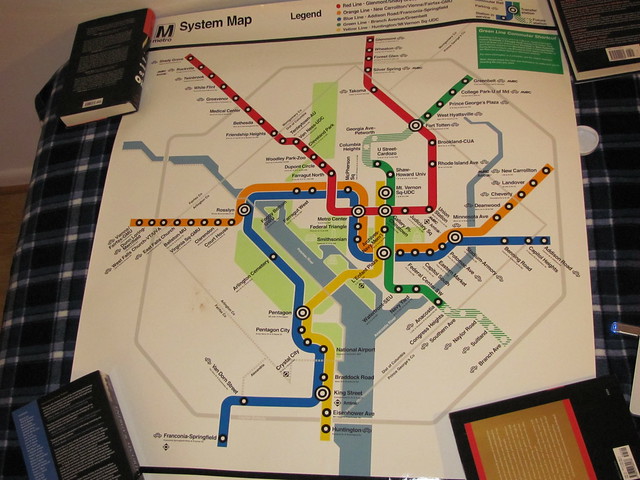
Rush+ Service, additional service, shortened station names (at least on THE map), the Silver Line makes an appearance...
http://www.wtop.com/?nid=654&sid=2792966
http://www.wtop.com/?nid=654&sid=2792966


The Yellow Line changes seem to make a lot of sense, particularly for the Franconia-Springfield branch. I don't really see the need for some Orange Line trains to head to Largo Town Center. The only people that benefits is people traveling the entire way over to/from west of Rosslyn on the Vienna branch. Is there really that much demand for one-seat service? As it is, it's an easy same-platform transfer.
Also, interesting that the Silver Line makes an appearance, but without any reference to where it's going. Most people can probably figure out (or already know) that it's going to serve Dulles, but why not mark that on the map?
My interpretation is that the rerouted Orange Line trains are extra service covering for the fact that some Blue Line trains are being turned into extended Yellow Line trains. Probably filling gaps where the Blue-turned-Yellow trains used to be.The Yellow Line changes seem to make a lot of sense, particularly for the Franconia-Springfield branch. I don't really see the need for some Orange Line trains to head to Largo Town Center. The only people that benefits is people traveling the entire way over to/from west of Rosslyn on the Vienna branch. Is there really that much demand for one-seat service? As it is, it's an easy same-platform transfer.
Probably because it won't be open for a few more years, and they don't want to confuse people by having them think the service is available now when it isn't.Also, interesting that the Silver Line makes an appearance, but without any reference to where it's going. Most people can probably figure out (or already know) that it's going to serve Dulles, but why not mark that on the map?
You are sort of correct here. The point isn't so much to relieve the "orange crush" as it is to deal with the coming of the Silver Line. Due to the orange crush, they cannot fit any more trains through the switch that merges the Blue & Orange lines on the Virginia side just west of the Rosslyn station. So in order to work in the new trains from the Silver line, they must reduce the number of Blue line trains coming that way.The Yellow Line changes seem to make a lot of sense, particularly for the Franconia-Springfield branch. I don't really see the need for some Orange Line trains to head to Largo Town Center. The only people that benefits is people traveling the entire way over to/from west of Rosslyn on the Vienna branch. Is there really that much demand for one-seat service? As it is, it's an easy same-platform transfer.
Also, interesting that the Silver Line makes an appearance, but without any reference to where it's going. Most people can probably figure out (or already know) that it's going to serve Dulles, but why not mark that on the map?
I'll surmise answers to both of these.
With the Orange line I suspect that it has to do with capacity. Additional trains are being added in an effort to relieve the 'Orange crush' that happens with trains going into DC from Virginia. At the same time, trains from Franconia/Springfield are being routed more directly downtown over the Yellow Line and proceeding up that line. This not only provides a more direct routing for many people into downtown, but it will also help relieve the current congestion in the tunnel under the river, which the Blue and Orange Lines share. This means there will be less Blue Line Trains east of downtown, so some Orange Line trains will be sent out the eastern end of the Blue line to provide the same level of service that that segment currently has.
Thanks Allen. I was wondering where the Silver Line was going to fit into the scheme of things. From the construction just east of the West Falls Church station, where the Silver Line joins the Orange, it sure looks like the Silvers will contiue downtown, but I'd not heard exactly what the plans were.You are sort of correct here. The point isn't so much to relieve the "orange crush" as it is to deal with the coming of the Silver Line. Due to the orange crush, they cannot fit any more trains through the switch that merges the Blue & Orange lines on the Virginia side just west of the Rosslyn station. So in order to work in the new trains from the Silver line, they must reduce the number of Blue line trains coming that way.The Yellow Line changes seem to make a lot of sense, particularly for the Franconia-Springfield branch. I don't really see the need for some Orange Line trains to head to Largo Town Center. The only people that benefits is people traveling the entire way over to/from west of Rosslyn on the Vienna branch. Is there really that much demand for one-seat service? As it is, it's an easy same-platform transfer.
Also, interesting that the Silver Line makes an appearance, but without any reference to where it's going. Most people can probably figure out (or already know) that it's going to serve Dulles, but why not mark that on the map?
I'll surmise answers to both of these.
With the Orange line I suspect that it has to do with capacity. Additional trains are being added in an effort to relieve the 'Orange crush' that happens with trains going into DC from Virginia. At the same time, trains from Franconia/Springfield are being routed more directly downtown over the Yellow Line and proceeding up that line. This not only provides a more direct routing for many people into downtown, but it will also help relieve the current congestion in the tunnel under the river, which the Blue and Orange Lines share. This means there will be less Blue Line Trains east of downtown, so some Orange Line trains will be sent out the eastern end of the Blue line to provide the same level of service that that segment currently has.
So the plan is to send some Blue line trains over the Yellow line which still has the capacity for more trains. This frees up slots on the combined Blue/Orange line through DC. Now since the Silver line isn't yet ready to run, rather than reducing capacity on the combined line and to help with the Orange Crush, they are temporarily adding more Orange line trains. However, the normal end point for the Blue line in Maryland would see reduced service if all those extra Orange line trains went to the normal end of the line @ New Carrollton. Remember, they sent some Blues onto the Yellow line. So for that reason, as well as to practice what will happen with the Silver line trains eventually, those temporary extra Oranges go to the Blue line terminus @ Largo TC. Once the Silver line starts running,then you will once again only see Orange line trains running to New Carrollton. Largo will see both Blue & Silver trains in the future.
Lines under construction have always been shown on Metro Maps.Great comments, and the Orange/Blue rationale makes a lot of sense.
As far as the phantom Silver Line, I guess it could be confusing but why even put it on the map at all, then? It's a stealth marketing campaign, I guess! :giggle:

I've seen that map before, can't remember where (maybe in a book about transit maps).Here's what the map looked like in 1982:
It's interesting that the split blue/orange line is coming back, but unlike the earlier iteration the "color" of the train will be driven by the origin, not the destination of the train. In 1982 a Ballston to Addison Road train would always be blue (because it had went to the end of the blue line). This summer, that same train will be an Orange train, because it's originating on the Orange side of the line.From any station, the Blue trains are headed toward National and Addison, which is where Blue trains go today, and the Orange trains are headed toward Ballston and New Carrollton, which is where those go today. So this gets riders used to boarding the correct color train to go from the central business district to an outlying area. However, they still board the wrong color train heading inbound, but from there, there are fewer choices and less opportunity for error.
Somehow this just seems inherently backwards to me. I mean does one care more about where the train came from, or where it is going?It's interesting that the split blue/orange line is coming back, but unlike the earlier iteration the "color" of the train will be driven by the origin, not the destination of the train. In 1982 a Ballston to Addison Road train would always be blue (because it had went to the end of the blue line). This summer, that same train will be an Orange train, because it's originating on the Orange side of the line.
:hi:Many thanks to Tracktwentynine and the crew at GGW for documenting all of this.
The split route operation made it so they didn't have to change any destination signs in the stations or on the trains (which I guess had roll signs back then).Actually, and I can remember this like it was yesterday, it was due to a car shortage and in the name of efficiency, this took care of a capacity issue. To put it bluntly, back in the day, the Orange Line was heavy on the New Carrollton end, while the Blue Line was heavier on the National Airport end...so, in the name of efficiency, Metro operated trains from National Airport to New Carrollton and from Addison Road to Ballston....then, after the Yellow Line opened between Gallery Place and the Airport, all things reverted back to normal.
It's right there at the top:Also, interesting that the Silver Line makes an appearance, but without any reference to where it's going. Most people can probably figure out (or already know) that it's going to serve Dulles, but why not mark that on the map?

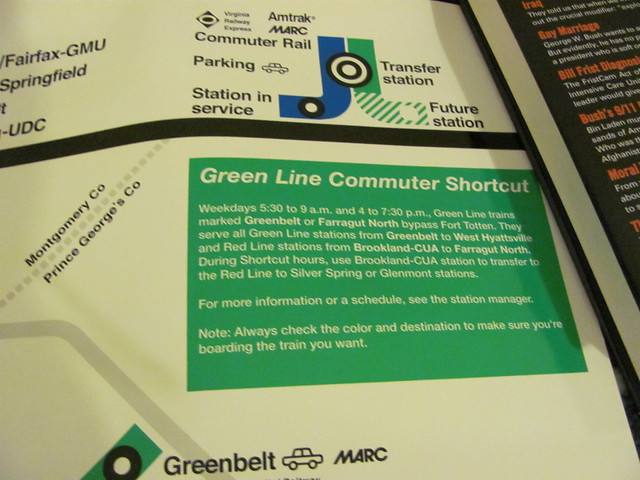
Some clarification on the Silver Line stub on the new map. The new map shows the five stations and 11.6 miles of Phase 1 which is under construction. The service over the Phase 1 section was supposed to start in late 2013, but probably will be early 2014. The new map will only be in use for less than 2 years, when a new one with the operational Phase 1 of the Silver Line will be issued.Thanks Allen. I was wondering where the Silver Line was going to fit into the scheme of things. From the construction just east of the West Falls Church station, where the Silver Line joins the Orange, it sure looks like the Silvers will contiue downtown, but I'd not heard exactly what the plans were.
True enough. To be honest, I had missed that. Still, it seems that previous maps showing "future service" also indicated on the map the specific stations that would be served in the future. This new map does not.It's right there at the top:Also, interesting that the Silver Line makes an appearance, but without any reference to where it's going. Most people can probably figure out (or already know) that it's going to serve Dulles, but why not mark that on the map?
There was a survey taken by WMATA that closed on March 21 for input on the proposed Silver Line station names in Fairfax County. The Greater Greater Washington blog had a recent discussion on the survey and suggested names which lists the name the Fairfax County Board came up with, with no apparent thought given to the importance of having names that are descriptive, short, and not muddled. All we can do is hope that the staff and WMATA board settle on clear names for the Silver Line and not fall victim to the whims of politics that resulted in station names like U Street/African-American Civil War Memorial/Cardozo. If the Silver Line is to open by November/December of 2013 - which is optimistic given the slip in delivery of the 7000 series cars, the station names will likely have to be finalized this year.Because those stations don't yet have names.
AlohaSomehow this just seems inherently backwards to me. I mean does one care more about where the train came from, or where it is going?
Could this 'new' practice be a projection of how METRO management looks at things? :unsure: :lol:
Interestingly, that's how they're identified internally, not to the public.AlohaSomehow this just seems inherently backwards to me. I mean does one care more about where the train came from, or where it is going?
Could this 'new' practice be a projection of how METRO management looks at things? :unsure: :lol:
Doesn't seem strange to me. In NYC, that is exactly how they Identify their trains. Remember the movie Pelham 123, that name is because the train starts at Pelham at 1:23. I laugh because it is funny that someone in Hollywood used a real naming convention :giggle:
But will the extra service not be operating in both directions? If it is, then it would only be identifying where the train came from in one direction, but will be showing its (more or less) destination line in the other. I say "more or less" because the Yellow Line will be extended to Greenbelt, which isn't its normal terminal, but it makes more sense showing it as a yellow line than as a Green Line.Thanks Ryan. Great post!
Somehow this just seems inherently backwards to me. I mean does one care more about where the train came from, or where it is going?It's interesting that the split blue/orange line is coming back, but unlike the earlier iteration the "color" of the train will be driven by the origin, not the destination of the train. In 1982 a Ballston to Addison Road train would always be blue (because it had went to the end of the blue line). This summer, that same train will be an Orange train, because it's originating on the Orange side of the line.
Enter your email address to join: